ڏاکڻي يورپ

ڏاکڻي يورپ (Southern Europe) هڪ جاگرافیائي اصطلاح آهي جيڪو خاص طور تي ڏکڻ يورپ ۾ واقع سڀني ملڪن کي بيان ڪرڻ لاءِ استعمال ڪيو ويندو آهي. مختلف وقتن ۾ ان جي استعمال ۾ پڻ مختلف معنا شامل آهن. جهڙوڪ سياسي تصور، لسانيات ۽ ثقافتي ۽ نباتات يا موسمي جاگرافي جي حوالي سان. ڏاکڻي يورپ جا اڪثر ملڪ ميڊيٽرينين سمنڊ سان ملن ٿا.
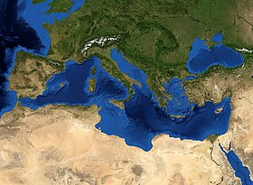
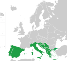
ڏاکڻي يورپ يورپ جو ڏاکڻي علائقو آهي. اهو پڻ ميڊيٽرينين يورپ جي نالي سان سڃاتو وڃي ٿو،[1] ڇاڪاڻ ته ان جي جاگرافيائي بيهڪ ميڊيٽرينين سمنڊ سان لڳل آهي. ڏکڻ يورپ جي وصفن ۾ شامل آهن ڪجھ يا سڀئي ملڪ ۽ علائقا: البانيا، اندورا، بوسنيا ۽ هرزيگوينا، بلغاريا، ڪروشيا، قبرص، جبرالٽر، يونان، اٽلي، مالٽا، موناڪو، مونٽينيگرو، اتر مقدونيا، پرتگال، سان مارينو، سربيا، سلووينيا، ڏاکڻي فرانس، اسپين، ترڪي (اوڀر ٿريس) ۽ ويٽيڪن سٽي.[2][3][4][5][6][7][8]
ڏاکڻي يورپ جو مرڪز ٽن جزائر تي آهي جيڪو يورپي براعظم جي انتهائي ڏکڻ ۾ واقع آهي. هي آهن Iberian Peninsula. اپينائن اپنينسولا. ۽ بلقان ٻيٽ. اهي ٽي جزيره يورپ جي باقي حصن کان جدا جدا جبلن جي قطارن جي ڪري، بالترتيب پيرنيس، الپس ۽ بلقان جبلن جي ڪري. ميڊيٽرينين سمنڊ جي دل ۾ انهن جزيرن جو مقام ۽ گڏوگڏ انهن جي جبلن جي راحت، انهن کي براعظم جي باقي علائقن کان مختلف قسم جي موسم (خاص طور تي ذيلي اڀرندڙ ميڊيٽرينين) مهيا ڪن ٿا. تنهن ڪري، سرڪوڪو گرم هوا جيڪا صحارا جي دل مان نڪرندي آهي، اٽلي جي مٿان هلندي آهي، الپائن آرڪ (پو وادي) جي اندروني حصي تائين وڃي ٿي. الپس سرڪوڪو کي باقي يورپ تائين پکڙجڻ کان روڪي ٿو. ۽، ان جي برعڪس، الپس ۽ پيرينيس اطالوي ۽ آئبرين جزائر کي برساتن ۽ برفاني هوائن کان ڏکڻ فرانس جهڙوڪ Mistral ۽ Tramontane کان بچائيندا آهن. جڏهن Mistral ۽ Tramontane اڏامي رهيا آهن، اهو فرانس جي ساحل تي هڪ "اوچتو" رجحان پيدا ڪري ٿو. اهي مٿاڇري جي پاڻي کي ٻاهر سمنڊ ڏانهن ڌڪيندا آهن ۽ سمنڊ جي ڪناري تائين اونڌو، ٿڌو پاڻي آڻيندا آهن. انڪري، فرانس جي ساحلن جي پاڻيءَ جو گرمي پد ان ڪري اونهاري ۾ به تمام ٿڌو آهي، ۽ باقي بحر روم جو نمائندو نه آهي. اهڙي ئي قسم جو واقعو بلقان جبل جي ٻن پهاڙين جي وچ ۾ ٿئي ٿو. اهي جبل، ان کان علاوه، آبادي جي بي گھرڻ لاءِ هڪ سنگين معذور بڻيل آهن، ڏکڻ يورپ کي خاص طور تي ميڊيٽرينين دنيا تي ڌيان ڏيڻ. تنهنڪري آبهوا ۽ ثقافتون تمام مخصوص آهن. ڏکڻ يورپ کي بيان ڪرڻ لاءِ مختلف طريقا استعمال ڪري سگھجن ٿا، جن ۾ سياسي، اقتصادي، تاريخي ۽ ثقافتي خاصيتون شامل آهن. ڏاکڻي يورپ به ان جي قدرتي خاصيتن جي ذريعي بيان ڪري سگهجي ٿو. ان جي جاگرافي، آبهوا ۽ نباتات. سياسي طور تي، ڏکڻ يورپي ملڪن مان نو يورپي يونين ميڊ گروپ ٺاهيندا آهن. ڏاکڻي يورپ پڻ لوئس طور تي ميڊيٽرينين بيسن جي يورپي حصي سان ملندڙ جلندڙ آهي.
Southern Europe is focused on the three peninsulas located in the extreme south of the European continent. These are the Iberian Peninsula, the Apennine Peninsula, and the Balkan Peninsula.[9][10] These three peninsulas are separated from the rest of Europe by towering mountain ranges, respectively by the Pyrenees, the Alps and the Balkan Mountains. The location of these peninsulas in the heart of the Mediterranean Sea, as well as their mountainous reliefs, provide them with very different types of climates (mainly subtropical Mediterranean) from the rest of the continent. So, the Sirocco hot wind that originates in the heart of the Sahara blows over Italy, going up to the interior of the Alpine arc (Po Valley). The Alps prevent the Sirocco from spreading to the rest of Europe. And, conversely, the Alps and the Pyrenees protect the Italian and Iberian Peninsulas from the rains and icy winds from the south of France such as the Mistral and the Tramontane. When the Mistral and the Tramontane are blowing, this provokes an "upwelling" phenomenon on the French coast. They push the surface waters out to sea and bring deeper, cooler waters up to the seaside. Consequently, the temperature of the waters of the French coasts are therefore very cool even in summer, and not representative of the rest of the Mediterranean.[11][12][13] This same kind of phenomenon takes place between the two slopes of the Balkan mountain range. These mountains have, moreover, been a serious handicap to population displacement, focusing southern Europe mainly on the Mediterranean world. The climate and cultures are therefore very specific.
Different methods can be used to define southern Europe, including its political, economic, historical, and cultural attributes. Southern Europe can also be defined by its natural features — its geography, climate, and flora. Politically, nine of the southern European countries form the EU Med Group. Southern Europe also loosely corresponds to the European part of the Mediterranean Basin.


- ↑ Southern Europe, وقت 2021-02-24 تي اصل کان آرڪائيو ٿيل, حاصل ڪيل 2024-08-21
- ↑ José María Magone; Magone, José María Magone (2003). The Politics of Southern Europe: Integration Into the European Union. Greenwood Publishing Group. pp. 292–. ISBN 978-0-275-97787-0. https://books.google.com/books?id=KOj2BwVxczUC&pg=PA292.
- ↑ Europe, Southern: Italy, Cyprus, Greece, European Turkey: Selected References. Air University Library. 1992. https://books.google.com/books?id=IZgyAQAAIAAJ.
- ↑ Encyclopedia of Social and Cultural Anthropology, Alan Barnard and Jonathan Spence. Retrieved 10 October 2015.
- ↑ UCF Libraries – Southern Europe
- ↑ Which Countries Make Up Southern Europe? WorldAtlas
- ↑ "Global Forest Resources Assessment 2000 - Chapter 30. Southern Europe". Food and Agriculture Organization of the United Nations. حاصل ڪيل 2021-11-26.
- ↑ Romania | History, Map, & Facts | Britannica
- ↑ Robert E. Dickinson (1969). The Makers of Modern Geography. Routledge Library Editions: Social and Cultural Geography. p. 16. ISBN 9781317907336. https://books.google.com/books?id=1yXJBQAAQBAJ. "He (August Zeune) divided Europe into its major divisions. Southern Europe falls into three units — the Pyrenean, Alpine, and Balkan peninsulas."
- ↑ "Europe: Physical Geography". National Geographic Society. حاصل ڪيل 21 February 2022.
Europe's main peninsulas are the Iberian, Italian, and Balkan, located in southern Europe
- ↑ "Mediterranean sea-surface temperature". ESA. حاصل ڪيل 2021-11-19.
- ↑ Barale, Vittorio. "Fig. 3.a: Sea surface temperature of the Mediterranean Sea (water masses and physical processes).". The coastal dimension of maritime spatial planning. ResearchGate. وقت Apr 23, 2023 تي اصل کان آرڪائيو ٿيل. حاصل ڪيل 2021-09-04. Unknown parameter
|url-status=ignored (مدد) - ↑ "2010-2019 SST in the Mediterranean". eo science for society. حاصل ڪيل 2021-11-19.
