مواد ڏانھن هلو

گريٽر لنڊن

کليل ڄاڻ چيڪلي، وڪيپيڊيا مان
گريٽر لنڊن ۽
لنڊن علائقو
ڪائونٽي

نيوهام ۾ سٽي هال، گريٽر لنڊن اٿارٽي جو هيڊ ڪوارٽر

انگلينڊ جي حدن ۾ گريٽر لنڊن رسمي ڪائونٽي (ڳاڙهو). درميان ۾ ننڍڙو (اڇو) گھريل علائقو لنڊن شھر آهي. ٻين گڏ ٿي گريٽر لنڊن ايڊمنسٽريو ايريا ٺاهڻ ٿا.
رياست يونائيٽيڊ ڪنگڊم
يونائيٽيڊ ڪنگڊم جو ملڪ انگلينڊ
قيام جي تاريخ پهرين اپريل، 1965ع
قائم ڪندڙ لنڊن گورنمينٽ ايڪٽ 1963ع
انگلينڊ جون رسمي ڪائونٽيون
لارڊ ليفٽننٽ ڪين اوليسا
ھاء شيرف انا ڊي (Ina De)
علائقو 1٬569 km2 (606 sq mi)
شمار 25هون of 48
شمار of 48
آبادي جي گھاٽائي [اوزا تبديل: needs a number]
ماڻھن جا قسم
  • 53.8% گورا (جنهن ۾ %36.8 برطانوي گورا آهن)
  • 20.7% ايشيائي
  • 13.5% ڪارا
  • 5.7% مخلوط نسل
  • 6.3% ٻيا
پارليامينٽ جا رڪن 73 MPs
73 برطانوي پارليامينٽ جا ميمبر
پوليس
  • سٽي آف لنڊن پوليس
  • ميٽروپوليٽن پوليس
ٽائيم زون Greenwich Mean Time (UTC)
(روشني بچائڻ وارو ٽائيم ) برطانيا جو اونھاري وارو ٽائيم (UTC+1)

گريٽر لنڊن (Greater London) انگلينڊ جو هڪ انتظامي علائقو آهي،[1] جيڪو لنڊن جي علائقي سان ملندڙ آهي، جيڪا لنڊن جي اڪثر شهري علائقن تي مشتمل آهي. ان ۾ 33 لوڪل گورنمينٽ ضلعا شامل آهن: لنڊن جا 32 بورو (Borough)، جيڪي هڪ رسمي ڪائونٽي ٺاهين ٿا، جن کي گريٽر لنڊن ۽ سٽي آف لنڊن پڻ سڏيو وڃي ٿو. گريٽر لنڊن اٿارٽي سڄي علائقي ۾ اسٽريٽجڪ لوڪل گورنمينٽ جي ذميوار آهي ۽ باقاعدي مقامي حڪومت بورو ڪائونسلن ۽ سٽي آف لنڊن ڪارپوريشن جي ذميواري آهي. گريٽر لنڊن اتر ۾ هرٽفورڊ شائر جي رسمي ڪائونٽيز، اتر-اوڀر ۾ ايسڪس، ڏکڻ-اوڀر ۾ ڪينٽ، ڏکڻ ۾ سري، ۽ اولهه ۾ برڪشائر ۽ بڪنگھم شائر سان لڳل آهي.

گريٽر لنڊن جي ايراضي 1,572 چورس ڪلوميٽر آهي ۽ آبادي سال 2021ع جي شمار جيمطابق 88,66,180 آهي. گريٽر لنڊن جي رسمي ڪائونٽي صرف ٿوري ننڍي آهي، جنهن جي ايراضي 1,569 چورس ڪلوميٽر (606 اسڪوائر ميل) آهي ۽ سال 2011ع ۾ 8,817,300 جي آبادي هئي. هي علائقو تقريبن مڪمل طور تي شهري آهي ۽ گريٽر لنڊن جي تعمير ٿيل علائقي جي اڪثريت تي مشتمل آهي. هي هرٽ فورڊ شائر، ايسڪس، ڪينٽ، سري ۽ برڪشائر ۾ پکڙيل آهي ۽ سال 2011 ع جي شمار ۾ 9,787,426 جي آبادي هئي. ڪو به انتظامي علائقو يا رسمي ڪائونٽي شهر جي حيثيت رکي ٿي پر سٽي آف لنڊن ۽ سٽي آف ويسٽ منسٽر الڳ الڳ حيثيت رکن ٿا. هي علائقو تاريخي طور مڊل سيڪس، ايسڪس، سري، ڪينٽ ۽ هارٽ فورڊ شائر جو حصو هو.

ٽيمز ندي (River Thames) علائقي جي وضاحت ڪندڙ جاگرافيائي خصوصيت آهي، جيڪو اولهه ۾ هيمپٽن جي ويجهو داخل ٿئي ٿي ۽ ڊيگنهام جي هيٺئين حصي مان نڪرڻ کان اڳ اوڀر طرف وهي ٿي. ٿامس نديءَ جون ڪيتريون ئي شاخون هن علائقي مان وهن ٿيون، پر هاڻي گهڻو ڪري ڪلورٽ ٿيل آهن ۽ لنڊن جي سيوريج سسٽم جو حصو بڻجن ٿيون. درياءَ جي اتر ۽ ڏکڻ ۾ زمين فوري طور تي برابر آهي، پر اڳتي هلي هيٺاهين ٽڪرين، خاص ڪري هيمپسٽڊ هيٿ، شوٽرز هل ۽ سڊنهام هل، ڏانهن وڌي ٿي. علائقي جو بلند ترين نقطو ويسٽرهام هائٽس (245 ميٽر (804 فوٽ)) آهي، جيڪو اتر ڊاونز جو حصو آهي. اتر-اوڀر علائقي ۾ ايپپنگ، هڪ قديم ٻيلي جو حصو آهي.

لنڊن شهر جي اينگلو-سيڪسن دور کان وٺي پنهنجي حڪومت هئي. پهرين لنڊن جي سڌي سڌي چونڊيل مقامي حڪومت لنڊن ڪائونٽي ڪائونسل هئي، جيڪا سال 1889ع ۾ لنڊن جي ڪائونٽي لاءِ قائم ڪئي وئي، جيڪا شهري علائقي جي بنيادي حصي کي ڍڪي ٿي. سال 1965ع ۾ ڪائونٽي کي ختم ڪيو ويو ۽ ان جي جاءِ تي گريٽر لنڊن، ٻن سطحن جو انتظامي علائقو جيڪو گريٽر لنڊن ڪائونسل، 32 لنڊن بورو ۽ سٽي آف لنڊن ڪارپوريشن پاران سنڀاليو ويو.[2] گريٽر لنڊن ڪائونسل کي سال 1986ع ۾ ختم ڪيو ويو ۽ ان جون ذميواريون گهڻو ڪري بورو (ڪائونٽين) جي حوالي ڪيون ويون. گريٽر لنڊن اٿارٽي سال 2000ع ۾ ٺهي.

انتظامي تاريخ

[سنواريو]

گريٽر لنڊن (Greater London) انگلينڊ جي علائقي جو نالو آهي جنھن ۾ لنڊن جون انتظامي حدون ۽ رسمي ليفٽيننٽ ڪائونٽيون اچن ٿيون جيڪي 33 مڪاني حڪومت وارن ضلعن يا بورو (boroughs) تي مشتمل آهن. انھن مان لنڊن شھر علحده ڪائونٽي آھي ۽ باقي ٻيا 32 مڪاني حڪومتن وارا ضلعا وري ھڪ الڳ ڪائونٽي آھن جنھن جو نالو گريٽر لنڊن ڪائونٽي آھي. اھي ٻہ ڪائونٽيون ملي ھي علائقو گريٽر لنڊن ٺاھيندڙن ٿيون. ھن علائقي ۾ گريٽر لنڊن اٿارٽي جنھن جو صدر مقام سائوٿ وارڪ ۾ آھي جا ھن سڄي علائقي جو مرڪزي مڪاني ادارو آھي جيڪو گريٽر لنڊن کي ڪنٽرول ڪري ٿو ۽ ان اٿارٽيءَ ۾ لنڊن جو ميئر ۽ لنڊن جي اسيمبلي اچي وڃن ٿا. اھا اٿارٽي ۽ لنڊن شھر جي ڪارپوريشن ٻہ مختلف ادارا آھن. ڪارپوريشن لنڊن شھر واري ڪائونٽي جي مڪاني حڪومت سڏجي ٿي ۽ اھا لنڊن شھر تائين محدود آھي. گريٽر لنڊن ڪائونٽي پھرين اپريل، 1965ع ۾ لنڊن گورنمينٽ ايڪٽ 1963ع تحت قائم ڪئي وئي.[3][4] ھي انھن ٻنھي ڪائونٽي کي ملائي گريٽر لندن ڪائونسل ٺاھي وئي جيڪا 1986ع تائين قائم رھي. سال 1996ع ۾ ان کي ٻيھر قائم ڪيو ويو ۽ سال 2000ع ۾ گريٽر لنڊن اٿارٽي قائم ڪئي وئي. ھي علائقو 1,572 چورس ڪلوميٽر تي مشتمل آهي جتي جي آبادي سال 2011ع جي مردم شماري تحت 81,74,000 آھي.[5] [6]

جاگرافي

[سنواريو]
Map of Greater London showing railway lines, primary roads, motorways, and suburban towns
The London postal district in red in contrast to Greater London

Greater London includes the most closely associated parts of the Greater London Urban Area and their historic buffers and includes, in five boroughs, significant parts of the Metropolitan Green Belt which protects designated greenfield land in a similar way to the city's parks. The closest and furthest boundaries[وضاحت گهربل] are with Essex to the northeast between Sewardstonebury next to Epping Forest and Chingford and with the Mar Dyke between Bulphan and North Ockendon. Greater London is also bounded by Hertfordshire to the north, Berkshire and Buckinghamshire to the west, Kent to the southeast and Surrey to the south and southwest. The highest point is Westerham Heights, in the North Downs and on the boundary with Kent, at 245 m (804 ft).[7] Central government has implemented small boundary changes. The greatest were the 1969 transfers of Farleigh to Surrey and Knockholt to Kent.[8] Others have included exchange of two Thames islands with Surrey and adjustments during the 1990s to parts of the boundaries of three boroughs near the M25.[9] The only part of Greater London outside the motorway is North Ockendon, the furthest land unit from its centre. The majority of Greater London forms the London Low Emission Zone (LEZ) and the Ultra Low Emission Zone (ULEZ).

The London postal district does not cover all of Greater London.[10][11][12]

گورننس

[سنواريو]

گريٽر لنڊن اٿارٽي

[سنواريو]

Greater London is under the strategic local governance of the Greater London Authority (GLA).[13] It consists of an elected assembly, the London Assembly, and an executive head, the Mayor of London.[14]

The current Mayor (not to be confused with the Lord Mayor of London) is Sadiq Khan. He is scrutinised by the elected London Assembly, which may amend his annual budget (by two-thirds majority) but otherwise lacks the power to block his directives. The headquarters of the GLA, previously at City Hall in Southwark, moved to The Crystal in Newham in January 2022.[15] The Mayor is responsible for Greater London's strategic planning and is required to produce or amend the London Plan each electoral cycle.

Mayor of London

[سنواريو]

The Mayor of London is a directly elected politician who, along with the London Assembly, is responsible for the strategic government of Greater London.

London Assembly

[سنواريو]

For elections to the London Assembly, London is divided into 14 constituencies, each formed from two or three boroughs. The City of London forms part of the City and East constituency.

UK Parliament

[سنواريو]

London is divided into 73 Parliamentary borough constituencies, formed from the combined area of several wards from one or more boroughs. Typically a borough is covered by two or three constituencies.

The London Region does not have city status granted by the Crown. The Cities of London and Westminster within it have received formal city status.[16][lower-alpha 1] Despite this, Greater London is commonly regarded as a city in the general senses of a conurbation and a municipality. A Lord Lieutenant of Greater London is appointed for its area, excluding the City of London. For the purposes of the Lieutenancies Act 1997, this area is defined as a county.[17]

The term "London" usually refers to region or to the conurbation, but not often to the ancient, tiny City of London.[18][19] That small area is often referred to as "the City" or "the Square Mile" and it forms the main financial district. Archaically, the urbanised area of London was known as the Metropolis. In common usage, the terms "London" and "Greater London" are usually used interchangeably.[18] Greater London is officially divided for some purposes, with varying definitions, into Inner London and Outer London. For some strategic planning purposes, it is divided into five sub-regions.

Local government

[سنواريو]

Greater London is divided into 32 London Boroughs, each governed by a London Borough council. The City of London has a unique government dating back to the 12th century and is separate from the county of Greater London, although is still part of the region served by the Greater London Authority.[18]

All London Borough councils belong to the London Councils association. Three London Boroughs carry the honorific title of Royal Borough: Kensington and Chelsea, Kingston, and Greenwich. Within the City of London are the liberties of Middle Temple and Inner Temple.

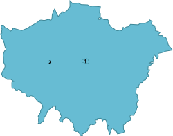
گريٽر لنڊن جون ڪائونٽيون

[سنواريو]

  1. لنڊن
  2. گريٽر لنڊن

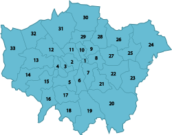
لنڊن شھر ۽ گريٽر لنڊن جي ٻن ڪائونٽين ۾ ايندڙ 33 مڪاني حڪومتن وارا ضلعا

[سنواريو]

  1. لنڊن، (سرڪاري طور تي ڪائونٽي جو حصو ناهي)
  2. ويسٽ منسٽر
  3. ڪينسنگٽن ۽ چيلسي
  4. ھيمرسمٿ ۽ فلھم
  5. وئنڊس ورٿ
  6. لئمبيٿ
  7. سائوٿ وارڪ
  8. ٽاور ھيمليٽس
  9. ھئڪني
  10. ازلنگٽن
  11. ڪيمڊن
  12. برينٽ
  13. ايئلنگ
  14. ھائونسلو
  15. رچمنڊ ٿيمز وارو
  16. ڪنگسٽن ٿيمز وارو
  17. مرٽن
  18. سٽن
  19. ڪروئيڊن
  20. براملي
  21. لووشم
  22. گرين وچ
  23. بيڪسلي
  24. ھي ورنگ
  25. بارڪنگ اينڊ ڊئگنھم
  26. ريڊ برج
  27. نيوھم
  28. والٿم فاريسٽ
  29. ھيرنگي
  30. انفيلڊ
  31. بارنيٽ
  32. ھارو
  33. ھلنگڊن

ڊيموگرافي

[سنواريو]
اصل مضمون جي لاءِ ڏسو Demographics of London
View from the top of Tolworth tower over the local area
High resolution view from the top of Tolworth Tower in South West London over the sprawling suburban housing that is typical in some areas of Greater London

With increasing industrialisation, London's population grew rapidly throughout the 19th and early 20th centuries, and it was the most populated city in the world until overtaken by New York in 1925. Its population peaked at 8,615,245 in 1939. There were an estimated 7,753,600 official residents in mid-2009.[20]

London's wider metropolitan area has a population of between 12 and 13 million depending on the definition of that area. According to Eurostat, London has been the most populous city and metropolitan area of the European Union.

The region covers an area of 1,579 square kilometres. The population density is 4,761 people per square kilometre, more than ten times that of any other British region. In terms of population, London is the 25th largest city and the 17th largest metropolitan region in the world.سانچو:When It is ranked 4th in the world in the number of US dollar billionaires residing in the city. It ranks as one of the most expensive cities in the world, alongside Tokyo and Moscow.

Ethnic groups

[سنواريو]

In the 2001 UK Census, 71.15% of the population classed their ethnic group as White, including White British (59.79%), White Irish (3.07%) or "Other White" (8.29%, mostly Greek-Cypriot, Italian, Polish and Portuguese). 12.09% classed themselves as British Asian, including Indian, Pakistani, Bangladeshi and "Other Asian" (mostly Sri Lankan, Arab and other Southern Asian ethnicities). 10.91% classed themselves as Black British (around 6% as Black African, 4% as Black Caribbean, 0.84% as "Other Black"). 3.15% were of mixed race; 1.12% as Chinese; and 1.58% as other (mostly Filipino, Japanese, Korean, Vietnamese and other "British Orientals"). 21.8% of inhabitants were born outside the European Union. Irish people, from both the Republic of Ireland and Northern Ireland, number about 200,000, as do the Scots and Welsh combined.

In January 2005, a survey of London's ethnic and religious diversity claimed that there were more than 300 languages spoken and more than 50 non-indigenous communities with a population of more than 10,000. Figures from the Office for National Statistics show that in 2006 London's foreign-born population was 2,288,000 (31%), up from 1,630,000 in 1997. The 2001 UK Census showed that 27.1% of the population were born outside the UK, and a slightly higher proportion were classed as Non-White.

In the 2011 UK Census, 59.79% of the population classed their ethnic group as White, including White British (44.89%), White Irish (2.15%) or "Other White" (12.65%, mostly Greek-Cypriot, Italian, Polish, Spanish, Colombians and Portuguese). 18.49% classed themselves as British Asian, including Indian, Pakistani, Bangladeshi and "Other Asian" (mostly Sri Lankan, Arab and other Southern Asian ethnicities). 13.32% classed themselves as Black British (7% as Black African, 4.22% as Black Caribbean, 2.08% as "Other Black"). 4.96% were of mixed race; and 3.44% as other (mostly Filipino, Japanese, Korean, Vietnamese and other "British Orientals").

The table shows the top 21 countries of birth of residents in 2011.[21] These figures do not give a fair indication of the total population of the specific ethnic groups associated with each country. For example, Londoners of Greek origin (from both Greece and Cyprus) number 300,000, since an organised Greek community has been established for nearly two centuries. The same can be said for Italian and French Londoners whose communities have been here for centuries (the French Embassy estimates there are between 300,000 and 400,000 French citizens living in the UK, with "a huge majority of them living in London").[22] Though a Polish community has existed in London since the late-Middle Ages, it was not significant in the 2001 Census but has grown significantly since 2004, when Poland joined the European Union and by June 2010; London had 122,000 Polish residents.[23] The German-born population figure may be misleading, however, because it includes British nationals born to parents serving in the British armed forces in Germany.

London has been a focus for immigration for centuries, whether as a place of safety or for economic reasons. Huguenots, Eastern European Jews, Cypriots and East African Asians are examples of the former; Irish, Bangladeshis and West Indians of the latter. The East End district around Spitalfields has been first home for several ethnic groups, which have subsequently moved elsewhere in London as they gained prosperity.

Ethnic group 2001[24] 2011[25] 2021[26]
Number % Number % Number %
White: British 4,287,861 59.79% 3,669,284 44.89% 3,239,281 36.81%
White: Irish 220,488 3.07% 175,974 2.15% 156,333 1.78%
White: Gypsy or Irish Traveller[Note 1] N/A 8,196 0.10% 7,031 0.08%
White: Roma[Note 2] N/A 37,689 0.43%
White: Other 594,854 8.29% 1,033,981 12.65% 1,290,838 14.67%
White: subtotal 5,103,203 71.15% 4,887,435 59.79% 4,731,172 53.76%
Asian or Asian British: Indian 436,993 6.09% 542,857 6.64% 656,272 7.46%
Asian or Asian British: Pakistani 142,749 1.99% 223,797 2.74% 290,549 3.30%
Asian or Asian British: Bangladeshi 153,893 2.15% 222,127 2.72% 322,054 3.66%
Asian or Asian British: Chinese[Note 3] 80,201 1.12% 124,250 1.52% 147,520 1.68%
Asian or Asian British: Other Asian 133,058 1.86% 398,515 4.88% 401,245 4.56%
Asian or Asian British: subtotal 946,894 13.20% 1,511,546 18.49% 1,817,640 20.66%
Black or Black British: African 378,933 5.28% 573,931 7.02% 697,054 7.92%
Black or Black British: Caribbean 343,567 4.79% 344,597 4.22% 345,405 3.93%
Black or Black British: Other Black 60,349 0.84% 170,112 2.08% 145,911 1.66%
Black or Black British: subtotal 782,849 10.92% 1,088,640 13.32% 1,188,370 13.50%
Mixed: White and Black Caribbean 70,928 0.99% 119,425 1.46% 132,555 1.51%
Mixed: White and Black African 34,182 0.48% 65,479 0.80% 77,341 0.88%
Mixed: White and Asian 59,944 0.84% 101,500 1.24% 125,188 1.42%
Mixed: Other Mixed 61,057 0.85% 118,875 1.45% 170,691 1.94%
Mixed: subtotal 226,111 3.15% 405,279 4.96% 505,775 5.75%
Other: Arab[Note 1] N/A 106,020 1.30% 139,791 1.59%
Other: Any other ethnic group 113,034 1.58% 175,021 2.14% 416,977 4.74%
Other: subtotal 113,034 1.58% 281,041 3.44% 556,768 6.33%
Total 7,172,091 100.00% 8,173,941 100.00% 8,799,725 100.00%
  1. 1.0 1.1 New category created for the 2011 census.
  2. New category created for the 2021 census.
  3. In 2001, listed under the 'Other ethnic group' heading.

Population

[سنواريو]
اصل مضمون جي لاءِ ڏسو Demographics of London
Greater London population from 1880 to 2016[27][28]

The population of the current area of Greater London rose from about 1.1 million in 1801 (when only about 850,000 people were in the urban area, while 250,000 were living in villages and towns not yet part of London) to an estimated 8.6 million in 1939, but declined to 6.7 million in 1988, before starting to rebound in the 1990s.

By 2006, the population had recovered to the level of 1970 (and the level of population in the 1920s). It has now surpassed the previous 1939 peak, and is over 9 million.

Figures here are for Greater London in its 2001 boundaries. Figures before 1971 have been reconstructed by the Office for National Statistics based on past censuses to fit the 2001 boundaries. Figures from 1981 onward are mid-year estimates (revised in August 2007), which are more accurate than the censuses, known to underestimate the population of London.

1891 5–6 April 5,572,012
1901 31 March – 1 April 6,506,954
1911 2–3 April 7,160,525
1921 19–20 June 7,386,848
1931 26–27 April 8,110,480
1939 Mid-year estimate 8,615,245
1951 8–9 April 8,196,978
1961 23–24 April 7,992,616
1965 Greater London formally created
1971 25–26 April 7,452,520
1981 Mid-year estimate 6,805,000[29]
1988 Mid-year estimate 6,729,300[30]
1991 Mid-year estimate 6,829,300[31]
2001 Mid-year estimate 7,322,400[32]
2002 Mid-year estimate 7,361,600[33]
2003 Mid-year estimate 7,364,100[34]
2004 Mid-year estimate 7,389,100[35]
2005 Mid-year estimate 7,456,100[36]
2006 Mid-year estimate 7,512,400[37]
2009 Mid-year estimate 7,753,600[37]
2013 Mid-year estimate 8,416,535[38]
2014 Mid-year estimate 8,546,761[39]
2016 Mid-year estimate 8,798,957[28]

معيشت

[سنواريو]
A profile of the economy of London in 2013

This is a chart of trend of regional gross value added (GVA) of Inner London at current basic prices published (pp. 240–253) by Office for National Statistics with figures in millions of British pounds sterling.

Year Regional Gross Value Added[lower-alpha 2] Agriculture[lower-alpha 3] Industry[lower-alpha 4] Services[lower-alpha 5]
1995 64,616 7 8,147 56,461
2000 92,330 6 10,094 82,229
2003 112,090 12 10,154 101,924

Eurostat data shows the GDP of Inner London to be 232 billion euros in 2009[40] and per capita GDP of 78,000 euros.

This is a chart of trend of regional gross value added of Outer London at current basic prices published (pp. 240–253) by Office for National Statistics with figures in millions of British pounds sterling.

Year Regional Gross Value Added[lower-alpha 2] Agriculture[lower-alpha 3] Industry[lower-alpha 4] Services[lower-alpha 5]
1995 44,160 51 10,801 33,307
2000 60,304 43 12,529 47,732
2003 69,420 69 13,081 54,462

Eurostat data shows the GDP of Outer London to be 103 billion euros in 2009[40] and per capita GDP of 21,460 euros.

مذهب

[سنواريو]
اصل مضمون جي لاءِ ڏسو Religion in London
Westminster Abbey. A World Heritage Site and location of the coronation of British monarchs.

The largest religious groupings are Christian (48.4%), Muslim (8.4%), Hindu (8.0%), Jewish (1.8%), Sikh (1.5%), and Buddhist (1.0%), alongside those of no religion (21.7%). The United Kingdom has traditionally been Christian, and London has a large number of churches, particularly in the city. St Paul's Cathedral in the City and Southwark Cathedral south of the river are Anglican administrative centres, while the clerical head of the Church of England and the worldwide Anglican Communion, the Archbishop of Canterbury, has his main residence at Lambeth Palace in the London Borough of Lambeth.

Important national and royal ceremonies are shared between St Paul's and Westminster Abbey. The Abbey is not to be confused with nearby Westminster Cathedral, the largest Roman Catholic cathedral in England and Wales. Religious practice in London is lower than in any other part of the UK or Western Europe and is around seven times lower than American averages. Despite the prevalence of Anglican churches, weekly observance is low within that denomination, although in recent years church attendance, particularly at evangelical Anglican churches in London, has started to increase.

London is home to sizeable Hindu, Sikh, Buddhist, Muslim and Jewish communities. Many Muslims live in Tower Hamlets and Newham; the most important Muslim buildings are the East London Mosque in Whitechapel and the London Central Mosque on the edge of Regent's Park. London's large Hindu community is in the north-western boroughs of Harrow and Brent, the latter containing one of Europe's largest Hindu temples, BAPS Shri Swaminarayan Mandir London.

Sikh communities are in East and West London, particularly Southall in the western borough of Ealing, which is also home to the largest Sikh temple in the capital. The majority of British Jews live in London, with significant communities in Stamford Hill (the most Orthodox Jewish area outside New York City and Israel) and St. John's Wood, Golders Green, and Edgware in North London.

تعليم

[سنواريو]

Publicly funded education has been administered through 33 LEAs, which correspond to the City of London and the 32 London boroughs, since the 1990 enactment of the Education Reform Act 1988.[41] From 1965 to 1990, 12 Inner London boroughs and the City of London were served by the Inner London Education Authority.[41]

The introduction of comprehensive schools, directed by Circular 10/65 in 1965, was mostly followed in Greater London; however, 19 grammar schools have been retained in some Outer London boroughs,[42] with Sutton having the most with five, followed by Bexley with four and others in five other boroughs. In these boroughs the state schools outperform the (relatively few) independent schools. In inner London, private schools always get the best results and are larger in number. At GCSE and A level, Outer London boroughs have broadly better results than Inner London boroughs.[43]

At GCSE, the best borough is Kingston upon Thames, closely followed by Sutton. Both boroughs have selective schools, and get the top two average GCSE results in England for LEAs. Next is Kensington and Chelsea, the third best in England, then Redbridge, Hammersmith and Fulham, Bromley, Barnet and Harrow. Only ten boroughs have GCSE results under the England average, and some inner-London boroughs have surprisingly good results considering where they lie on the scale of deprivation, e.g. Lambeth. Overall at GCSE in 2009, Greater London had the best results for regions of England. Greater London is generally a prosperous region, and prosperous areas generally have good GCSE results. The City of London has no state schools, just two independent schools. Haringey and Kensington and Chelsea have the most people that pass no GCSEs.[حوالو گهربل]

At A-level, the average results for LEAs are disappointing compared to their good GCSE results. Although Kingston upon Thames gets the best GCSE results in England, at A-level it is not even above average. Sutton gets the best A-level results in London and in England. Three of the schools in the top four at A-level in London are in Sutton. It has only one independent school. The few other boroughs with above-average A-level results are Havering, Barnet, Bexley, Redbridge, and Ealing. The poor A-level results in many London boroughs is explained by the quantity of independent schools getting good A-level results. The state school system is often bypassed at age 16 by the more able pupils. Some London boroughs need more good sixth form colleges.[حوالو گهربل]

The region's 34 further education colleges are funded through the Skills Funding Agency and the Young People's Learning Agency. Large colleges include Kingston College, Havering College of Further and Higher Education, and Croydon College.

Universities

[سنواريو]
University College London, a founding constituent of the University of London

The University of London has 20 federated colleges and schools. The two main constituents of the University of London are (in order of total funding) University College London (UCL) and King's College London (KCL). Imperial College was part of the University of London until 2007, and is now an independent university. UCL, KCL and Imperial have very large research grants – some of the largest in England after Cambridge and Oxford, UCL and Imperial receive around £600 million each which is more than twice as much as any other in the region. The next largest institution by funding is Queen Mary University of London, followed by City, University of London. London is also home to the London School of Economics and Political Science (LSE), one of the few solely social science institutions in the world. Together with UCL and Imperial, they make up the London vertex of the Golden Triangle universities, the other institutions being Oxford and Cambridge. The region has many medical schools although these are part of other institutions such as UCL, KCL and Imperial. The Royal Veterinary College is based in Camden (with another site in North Mymms in Hertfordshire).

50% of students come from the region, and around 30% from other regions. Most students from other regions come from South East England, the East of England, and, to a lesser degree, South West England; the vast majority are from the south of England. Over 50% students native to the region stay in the region, with 15% going to South East England, 30% to either Scotland, Wales or the North East and around 5% go elsewhere. London is a draw for UK graduates from all over the UK.

Over 70% of UK students to graduate from the University of London remain in London; just under 15% go to the South-East, and just over 5% go to the East of England and 10% elsewhere.

ڀينر شهر

[سنواريو]

گريٽر لنڊن اٿارٽي جو ھيٺ ڏنل شهرن سان ڀينرن شهرن جو اتفاق آهي.[44]

ملڪ شهر علائقو Year
چين چين شنگهائي Shanghai Municipality 2009[45]
چين چين بيجنگ Beijing Municipality 2006[46]
فرانس فرانس پيرس Île-de-France 2001
جرمني جرمني برلن Berlin 2000
روس روس ماسڪو Russian federal city 2002
گڏيل آمريڪي رياستون آمريڪا جون گڏيل رياستون نيو يارڪ سٽي New York 2001[47]
جاپان جاپان ٽوڪيو Tokyo 2005
ڪروشيا ڪروشيا زغرب City of Zagreb 2009
ڀارت ڀارت ممبئي Maharashtra

پڻ ڏسو

[سنواريو]
Geographical
Political
Historical
Others

خارجي لنڪس

[سنواريو]

حوالا

[سنواريو]
  1. "London Government Act 1963 - Latest Available". legislation.gov.uk. وقت 29 October 2021 تي اصل کان آرڪائيو ٿيل. حاصل ڪيل 2021-10-12.  Unknown parameter |url-status= ignored (مدد)
  2. "London Government Act 1963 - Latest Available". legislation.gov.uk. وقت 29 October 2021 تي اصل کان آرڪائيو ٿيل. حاصل ڪيل 2021-10-12.  Unknown parameter |url-status= ignored (مدد)
  3. "London Government Act 1963" (PDF). Legislation.gov.uk. حاصل ڪيل 19 August 2017. 
  4. "Administration of Justice Act 1964" (PDF). Legislation.gov.uk. حاصل ڪيل 19 August 2017. 
  5. Watson, Jo. "Access to Nature Regional Targeting Plan – LONDON" (PDF). Natural England. وقت 14 July 2014 تي اصل (pdf) کان آرڪائيو ٿيل. 
  6. "T 08: 2011 Census – Population and Household Estimates for England and Wales, March 2011" (PDF). Office for National Statistics. حاصل ڪيل 16 July 2012. 
  7. Bathurst, David (2012). Walking the county high points of England. Chichester: Summersdale. pp. 82–85. ISBN 978-1-84-953239-6. 
  8. The Greater London, Kent and Surrey Order, 1968
  9. The Greater London and Surrey Order, 1970
  10. Laurence Cawley (5 July 2013). "London Government Act: Essex, Kent, Surrey and Middlesex 50 years on". BBC News. https://www.bbc.co.uk/news/uk-england-23518687. 
  11. "House of Commons Hansard Debates for 23 Jun 2009 (pt 0008)". Publications.parliament.uk. وقت 5 August 2017 تي اصل کان آرڪائيو ٿيل. حاصل ڪيل 19 August 2017.  Unknown parameter |url-status= ignored (مدد)
  12. [1][مئل ڳنڍڻو] Royal Mail (2004)
  13. Jones, B. et al., Politics UK, (2004)
  14. Arden Chambers Barristers, A Guide to the Greater London Authority Act, (2000)
  15. Cox, Michael. "'London is moving east': City Hall's Crystal move confirmed for New Year". Newham Recorder. وقت 2 December 2021 تي اصل کان آرڪائيو ٿيل. حاصل ڪيل 2021-12-02.  Unknown parameter |url-status= ignored (مدد)
  16. Westminster City Council – One City – An Introduction آرڪائيو ڪيا ويا 22 May 2009 حوالو موجود آهي وي بيڪ مشين.
  17. HMSO, Lieutenancies Act 1997 آرڪائيو ڪيا ويا 30 October 2007 حوالو موجود آهي وي بيڪ مشين., (1997)
  18. 18.0 18.1 18.2 Travers, T., The Politics of London, (2004)
  19. Mills, A., Dictionary of London Place Names, (2001), Oxford
  20. "2009 Round Demographic Projections for the London Plan" (PDF). وقت 2 April 2013 تي اصل (PDF) کان آرڪائيو ٿيل. حاصل ڪيل 2020-01-17.  Unknown parameter |url-status= ignored (مدد)
  21. "Greater London Authority – Summary of 'Country-of-Birth' in London" (PDF). Greater London Authority. وقت 27 May 2008 تي اصل (PDF) کان آرڪائيو ٿيل. حاصل ڪيل 6 June 2008.  Unknown parameter |url-status= ignored (مدد)
  22. "London, France's sixth biggest city". BBC News. 30 May 2012. https://www.bbc.co.uk/news/magazine-18234930. 
  23. "Polish people in the UK". Office for National Statistics. وقت 19 March 2011 تي اصل کان آرڪائيو ٿيل.  Unknown parameter |url-status= ignored (مدد)
  24. "2001 census – theme tables". NOMIS. وقت 20 November 2012 تي اصل کان آرڪائيو ٿيل. حاصل ڪيل 5 September 2014.  Unknown parameter |url-status= ignored (مدد)
  25. "Ethnic Group by measures". NOMIS. وقت 3 September 2014 تي اصل کان آرڪائيو ٿيل. حاصل ڪيل 2 September 2014.  Unknown parameter |url-status= ignored (مدد)
  26. "TS021 - Ethnic group". Nomis: Official Census and Labour Market Statistics. حاصل ڪيل 30 March 2023. 
  27. "Home - Office for National Statistics". www.ons.gov.uk. وقت 19 December 1996 تي اصل کان آرڪائيو ٿيل. حاصل ڪيل 15 July 2020.  Unknown parameter |url-status= ignored (مدد)
  28. 28.0 28.1 "2016 Mid-Year Estimates – London Datastore". وقت 7 May 2019 تي اصل کان آرڪائيو ٿيل. حاصل ڪيل 7 May 2019.  Unknown parameter |url-status= ignored (مدد)
  29. "T 08: Quinary age group and sex for local authorities in England and Wales; estimated resident population based on the 1991 Census; Mid-1981 Population Estimates.". Office for National Statistics. وقت 11 January 2009 تي اصل کان آرڪائيو ٿيل. حاصل ڪيل 22 August 2007.  Unknown parameter |url-status= ignored (مدد)
  30. "T 08h: Mid-1988 Population Estimates; Quinary age groups and sex for local authorities in England and Wales; estimated resident population revised in light of results of the 2001 Census". Office for National Statistics. وقت 27 June 2008 تي اصل کان آرڪائيو ٿيل. حاصل ڪيل 22 August 2007.  Unknown parameter |url-status= ignored (مدد)
  31. "T 09a: Mid-1991 Population Estimates; Quinary age groups and sex for local authorities in the United Kingdom; estimated resident population". Office for National Statistics. وقت 11 January 2009 تي اصل کان آرڪائيو ٿيل. حاصل ڪيل 22 August 2007.  Unknown parameter |url-status= ignored (مدد)
  32. "T 08: Selected age groups for local authorities in the United Kingdom; estimated resident population; revised in light of the local authority population studies; Mid-2001 Population Estimates". Office for National Statistics. وقت 11 January 2007 تي اصل کان آرڪائيو ٿيل. حاصل ڪيل 22 August 2007.  Unknown parameter |url-status= ignored (مدد)
  33. "T 09L: Quinary age groups and sex for local authorities in the United Kingdom; estimated resident population Mid-2002 Population Estimates; reflecting the revisions due to improved international migration". Office for National Statistics. وقت 11 January 2009 تي اصل کان آرڪائيو ٿيل. حاصل ڪيل 22 August 2007.  Unknown parameter |url-status= ignored (مدد)
  34. "T 09m: Quinary age groups and sex for local authorities in the United Kingdom; estimated resident population Mid-2003 Population Estimates; reflecting the revisions due to improved international migration". Office for National Statistics. وقت 11 January 2009 تي اصل کان آرڪائيو ٿيل. حاصل ڪيل 22 August 2007.  Unknown parameter |url-status= ignored (مدد)
  35. "T 09n: Quinary age groups and sex for local authorities in the United Kingdom; estimated resident population Mid-2004 Population Estimates; reflecting the revisions due to improved international migration". Office for National Statistics. وقت 11 January 2009 تي اصل کان آرڪائيو ٿيل. حاصل ڪيل 22 August 2007.  Unknown parameter |url-status= ignored (مدد)
  36. "T 09p: Quinary age groups and sex for local authorities in the United Kingdom; estimated resident population Mid-2005 Population Estimates; reflecting the revisions due to improved international migration". Office for National Statistics. وقت 11 January 2009 تي اصل کان آرڪائيو ٿيل. حاصل ڪيل 22 August 2007.  Unknown parameter |url-status= ignored (مدد)
  37. 37.0 37.1 "T 08: 2011 Census – Population and Household Estimates for England and Wales, March 2011" (PDF). Office for National Statistics. وقت 24 February 2016 تي اصل (PDF) کان آرڪائيو ٿيل. حاصل ڪيل 16 July 2012.  Unknown parameter |url-status= ignored (مدد)
  38. "Population Estimates for UK, England and Wales, Scotland and Northern Ireland, Mid-2013". وقت 24 September 2015 تي اصل کان آرڪائيو ٿيل. حاصل ڪيل 3 July 2014.  Unknown parameter |url-status= ignored (مدد)
  39. "MYE2: Population Estimates by single year of age and sex for local authorities in the UK, mid-2014". ONS. Office for National Statistics. وقت 24 September 2015 تي اصل کان آرڪائيو ٿيل. حاصل ڪيل 9 July 2015.  Unknown parameter |url-status= ignored (مدد)
  40. 40.0 40.1 "Regional GDP per capita in 2009: seven capital regions in the ten first places" (PDF). وقت 23 March 2012 تي اصل (PDF) کان آرڪائيو ٿيل. حاصل ڪيل 17 May 2012.  Unknown parameter |url-status= ignored (مدد)
  41. 41.0 41.1 Tomlinson, S., Education in a post-welfare society, (2001)
  42. BBC News – What future for grammar schools? آرڪائيو ڪيا ويا 11 October 2007 حوالو موجود آهي وي بيڪ مشين.. 15 February 2003.
  43. OFSTED, Improvements in London schools 2000–06 آرڪائيو ڪيا ويا 5 June 2007 حوالو موجود آهي وي بيڪ مشين., (2006)
  44. The Mayor of London's City Partnerships webpage آرڪائيو ڪيا ويا 27 September 2007 حوالو موجود آهي وي بيڪ مشين.
  45. Sister City Relationships between China and the United Kingdom آرڪائيو ڪيا ويا 11 March 2019 حوالو موجود آهي وي بيڪ مشين., Chinese Embassy, 16 July 2015.
  46. "Beijing, London to be sister cities آرڪائيو ڪيا ويا 15 December 2018 حوالو موجود آهي وي بيڪ مشين.", China Daily, 11 April 2006. Retrieved on 6 June 2006.
  47. "Sister City – London". nyc.gov. وقت 14 January 2007 تي اصل کان آرڪائيو ٿيل. حاصل ڪيل 3 February 2007.  Unknown parameter |url-status= ignored (مدد)


حوالي جي چڪ: "lower-alpha" نالي جي حوالن جي لاءِ ٽيگ <ref> آهن، پر لاڳاپيل ٽيگ <references group="lower-alpha"/> نہ مليو