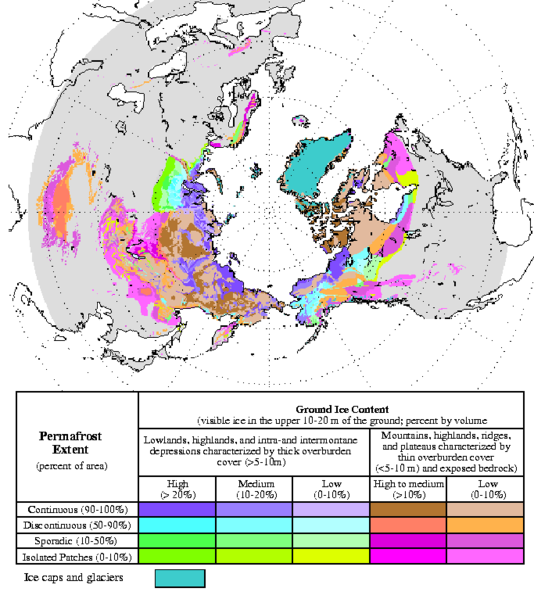
فائل:Circum-Arctic Map of Permafrost and Ground Ice Conditions.png
ڏيک

هن پيش-نگاھ جي ماپ: 534*599 پڪزلس. ٻيا تحلل:214*240 پڪزلس | 428*480 پڪزلس | 683*766 پڪزلس
اصلوڪو فائيل (683 × 766 عڪسلون، فائيل سائيز: 29 KB، MIME ٽائيپ: image/png)
فائيل جي سوانح
ڪنھن بہ تاريخ/وقت تي ٽڙڪ ڪري ڏسندا تہ ان وقت اهو فائيل ڪيئن هو.
| تاريخ/وقت | ٽِڪِلِي | ماپَ | واپرائيندڙ | راءِ | |
|---|---|---|---|---|---|
| هاڻوڪو نسخو | 13:21, 23 مارچ 2015 |  | 683 × 766 (29 KB) | RokerHRO | optipng -o7 -i0 → 35.32% decrease |
| 18:40, 21 مَئي 2008 |  | 683 × 766 (44 KB) | Sagredo | {{Information |Description=Circum-Arctic Map of Permafrost and Ground Ice Conditions |Source=http://nsidc.org/data/docs/fgdc/ggd318_map_circumarctic/index.html |Date=1998, revised February 2001 |Author=Brown, J., O.J. Ferrians, Jr., J.A. Heginbottom, and |
ڳنڍڻا
هن فائيل سان هيٺيان صفحا ڳنڍيل آهن.
فائيل جو ٻين وڪيز تي استعمال
ھيٺيون وڪيز بہ ھيءُ فائيل استعمال ڪن ٿيون:
- bxr.wikipedia.org تي استعمال
- ca.wikipedia.org تي استعمال
- ckb.wikipedia.org تي استعمال
- cs.wikipedia.org تي استعمال
- de.wikipedia.org تي استعمال
- el.wikipedia.org تي استعمال
- en.wikipedia.org تي استعمال
- eo.wikipedia.org تي استعمال
- eu.wikipedia.org تي استعمال
- fa.wikipedia.org تي استعمال
- fr.wikipedia.org تي استعمال
- gl.wikipedia.org تي استعمال
- ha.wikipedia.org تي استعمال
- he.wikipedia.org تي استعمال
- ויקיפדיה:ערכים מומלצים/המלצות קודמות/פברואר 2017
- קפאת-עד
- תבנית:ערך מומלץ 19 בפברואר 2017
- תבנית:ערך מומלץ 20 בפברואר 2017
- פורטל:ערכים מומלצים/ערכים/קפאת-עד
- ויקיפדיה:ערכים מומלצים/המלצות קודמות/אפריל 2022
- ויקיפדיה:ערכים מומלצים/המלצות קודמות/פברואר 2024
- תבנית:ערך מומלץ 4 באפריל 2022
- תבנית:ערך מומלץ 14 בפברואר 2024
- hr.wikipedia.org تي استعمال
- id.wikipedia.org تي استعمال
- it.wikipedia.org تي استعمال
- ko.wikipedia.org تي استعمال
- mk.wikipedia.org تي استعمال
- ms.wikipedia.org تي استعمال
- ro.wikipedia.org تي استعمال
- ru.wikipedia.org تي استعمال
- simple.wikipedia.org تي استعمال
- si.wikipedia.org تي استعمال
- sl.wikipedia.org تي استعمال
- sv.wikipedia.org تي استعمال
- tr.wikipedia.org تي استعمال
- uk.wikipedia.org تي استعمال
- zh.wikipedia.org تي استعمال


