
فائل:Circum-Arctic Map of Permafrost and Ground Ice Conditions.png
هن پيش-نگاھ جي ماپ: 534*599 پڪزلس. ٻيا تحلل:214*240 پڪزلس | 428*480 پڪزلس | 683*766 پڪزلس
اصلوڪو فائيل (683 × 766 عڪسلون، فائيل سائيز: 29 KB، MIME ٽائيپ: image/png)

|
This map image could be re-created using vector graphics as an SVG file. This has several advantages; see Commons:Media for cleanup for more information. If an SVG form of this image is available, please upload it and afterwards replace this template with
{{vector version available|new image name}}.
It is recommended to name the SVG file “Circum-Arctic Map of Permafrost and Ground Ice Conditions.svg”—then the template Vector version available (or Vva) does not need the new image name parameter. |
تَتُ
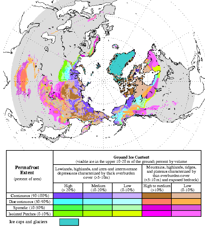
| تشريح | Circum-Arctic Map of Permafrost and Ground Ice Conditions |
| تاريخ | 1998, revised February 2001 |
| ذريعو | http://nsidc.org/data/docs/fgdc/ggd318_map_circumarctic/index.html |
| ليکڪ | Brown, J., O.J. Ferrians, Jr., J.A. Heginbottom, and E.S. Melnikov. 1998, revised February 2001. Circum-arctic map of permafrost and ground ice conditions. Boulder, CO: National Snow and Ice Data Center/World Data Center for Glaciology |
لائيسنسڪاري
This work is in the public domain in the United States because it is a work prepared by an officer or employee of the United States Government as part of that person’s official duties under the terms of Title 17, Chapter 1, Section 105 of the US Code.
Note: This only applies to original works of the Federal Government and not to the work of any individual U.S. state, territory, commonwealth, county, municipality, or any other subdivision. This template also does not apply to postage stamp designs published by the United States Postal Service since 1978. (See § 313.6(C)(1) of Compendium of U.S. Copyright Office Practices). It also does not apply to certain US coins; see The US Mint Terms of Use.
|
 | |
| This file has been identified as being free of known restrictions under copyright law, including all related and neighboring rights. | ||
فائيل جي سوانح
ڪنھن بہ تاريخ/وقت تي ٽڙڪ ڪري ڏسندا تہ ان وقت اهو فائيل ڪيئن هو.
| تاريخ/وقت | آڱوٺي ننھن | ماپَ | واپرائيندڙ | راءِ | |
|---|---|---|---|---|---|
| موجود نسخو | 13:21, 23 مارچ 2015 | | 683 × 766 (29 KB) | RokerHRO | optipng -o7 -i0 → 35.32% decrease |
| 18:40, 21 مَئي 2008 |  | 683 × 766 (44 KB) | Sagredo | {{Information |Description=Circum-Arctic Map of Permafrost and Ground Ice Conditions |Source=http://nsidc.org/data/docs/fgdc/ggd318_map_circumarctic/index.html |Date=1998, revised February 2001 |Author=Brown, J., O.J. Ferrians, Jr., J.A. Heginbottom, and |
ڳنڍڻا
هن فائيل سان هيٺيان صفحا ڳنڍيل آهن.
گلوبل فائيل جو استعمال
ھيٺيون وڪيز بہ ھيءُ فائيل استعمال ڪن ٿيون:
- bxr.wikipedia.org تي استعمال
- ca.wikipedia.org تي استعمال
- ckb.wikipedia.org تي استعمال
- cs.wikipedia.org تي استعمال
- de.wikipedia.org تي استعمال
- el.wikipedia.org تي استعمال
- en.wikipedia.org تي استعمال
- eo.wikipedia.org تي استعمال
- eu.wikipedia.org تي استعمال
- fa.wikipedia.org تي استعمال
- fr.wikipedia.org تي استعمال
- gl.wikipedia.org تي استعمال
- ha.wikipedia.org تي استعمال
- he.wikipedia.org تي استعمال
- ויקיפדיה:ערכים מומלצים/המלצות קודמות/פברואר 2017
- קפאת-עד
- תבנית:ערך מומלץ 19 בפברואר 2017
- תבנית:ערך מומלץ 20 בפברואר 2017
- פורטל:ערכים מומלצים/ערכים/קפאת-עד
- ויקיפדיה:ערכים מומלצים/המלצות קודמות/אפריל 2022
- ויקיפדיה:ערכים מומלצים/המלצות קודמות/פברואר 2024
- תבנית:ערך מומלץ 4 באפריל 2022
- תבנית:ערך מומלץ 14 בפברואר 2024
- hr.wikipedia.org تي استعمال
- id.wikipedia.org تي استعمال
- it.wikipedia.org تي استعمال
- ko.wikipedia.org تي استعمال
- ms.wikipedia.org تي استعمال
- ro.wikipedia.org تي استعمال
- ru.wikipedia.org تي استعمال
- simple.wikipedia.org تي استعمال
- si.wikipedia.org تي استعمال
- sl.wikipedia.org تي استعمال
- sv.wikipedia.org تي استعمال
- tr.wikipedia.org تي استعمال
- uk.wikipedia.org تي استعمال
- zh.wikipedia.org تي استعمال