
فائل:Muhammad al-Idrisi - Oxford transcript of V-4.jpg

هن پيش-نگاھ جي ماپ: 800*552 پڪزلس. ٻيا تحلل:320*221 پڪزلس | 640*441 پڪزلس | 1,024*706 پڪزلس | 1,280*883 پڪزلس | 2,102*1,450 پڪزلس
اصلوڪو فائيل (2,102 × 1,450 عڪسلون، فائيل سائيز: 1.72 MB، MIME ٽائيپ: image/jpeg)
تَتُ
| تشريح |
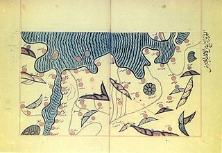
English: Muhammad al-Idrisi. Oxford transcript of V-4. The map displays: the northern shoreline of Marmara Sea, Gallipoli Peninsula, Aegean Sea shoreline from the delta of Maritsa River to Peloponnese Peninsula, region Macedonia, parts of Central Greece and Thessaly |
| تاريخ | 12 century |
| ذريعو | Scanned from book "Балканският полуостров изобразен в картите на Ал-Идриси", Стоянка Кендерова, Боян Бешевлиев, София, 1990 |
| ليکڪ | Muhammad al-Idrisi (1100 – 1165 or 1166) |
لائيسنسڪاري
|
This is a faithful photographic reproduction of a two-dimensional, public domain work of art. The work of art itself is in the public domain for the following reason:
The official position taken by the Wikimedia Foundation is that "faithful reproductions of two-dimensional public domain works of art are public domain". This photographic reproduction is therefore also considered to be in the public domain in the United States. In other jurisdictions, re-use of this content may be restricted; see Reuse of PD-Art photographs for details. {{PD-Art}} template without license parameter: please specify why the underlying work is public domain in both the source country and the United States
(Usage: {{PD-Art|1=|deathyear=''year of author's death''|country=''source country''}}, where parameter 1= can be PD-old-auto, PD-old-auto-expired, PD-old-auto-1996, PD-old-100 or similar. See Commons:Multi-license copyright tags for more information.) | ||||
فائيل جي سوانح
ڪنھن بہ تاريخ/وقت تي ٽڙڪ ڪري ڏسندا تہ ان وقت اهو فائيل ڪيئن هو.
| تاريخ/وقت | ٽِڪِلِي | ماپَ | واپرائيندڙ | راءِ | |
|---|---|---|---|---|---|
| هاڻوڪو نسخو | 00:32, 15 جنوري 2009 | | 2,102 × 1,450 (1.72 MB) | Spiritia | == Summary == {{Information |Description= {{en|Muhammad al-Idrisi. Oxford transcript of V-4.<br/>The map displays: the northern shoreline of Marmara Sea, Gallipoli Peninsula, Aegean Sea shoreline from the delta of Maritsa River to Peloponnese Peninsula, r |
ڳنڍڻا
هن فائيل سان هيٺيان صفحا ڳنڍيل آهن.
فائيل جو ٻين وڪيز تي استعمال
ھيٺيون وڪيز بہ ھيءُ فائيل استعمال ڪن ٿيون:
- bg.wikipedia.org تي استعمال
- en.wikipedia.org تي استعمال
- gl.wikipedia.org تي استعمال
- it.wikipedia.org تي استعمال
- kn.wikipedia.org تي استعمال
- mt.wikipedia.org تي استعمال
- sq.wikipedia.org تي استعمال
- su.wikipedia.org تي استعمال
- th.wikipedia.org تي استعمال
- xmf.wikipedia.org تي استعمال