
فائل:Odoacer 480ad.jpg

اصلوڪو فائيل (900 × 545 عڪسلون، فائيل سائيز: 701 KB، MIME ٽائيپ: image/jpeg)

|
This historical map image could be re-created using vector graphics as an SVG file. This has several advantages; see Commons:Media for cleanup for more information. If an SVG form of this image is available, please upload it and afterwards replace this template with
{{vector version available|new image name}}.
It is recommended to name the SVG file “Odoacer 480ad.svg”—then the template Vector version available (or Vva) does not need the new image name parameter. |


تَتُ
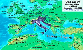
| تشريح | Odoacer's Kingdom of Italy in 480 AD. |
| تاريخ | |
| ذريعو | ڪم پنھنجايو |
| ليکڪ | Thomas Lessman (Contact!) |
| اجازت (ھن فائيل کي وَراستعمال ڪندي) |
I, the copyright holder of this work, hereby publish it under the following license: ھي فائيل ڪريئيٽو ڪامنز انتساب-ھڪجھڙي ڀاڱيداري 3.0 انپورٽڊ اجازتنامي ھيٺ اجازتنامو ڏنل آھي.
|
| Other versions | See Below |
Map Summary
Original Source URL: http://www.thomaslessman.com/History/images/East-Hem_480ad.jpg or www.WorldHistoryMaps.info
This map of the Kingdom of Odoacer in 480 AD is a zoomed-in version of Thomas Lessman's map of the East-Hem 480 AD, also available at www.WorldHistoryMaps.info.
The highlighted areas represent Odoacer's Kingdom of Italy, after the capture of Italy (476), conquest of Sicily from the Vandals (477) and the annexation of Dalmatia after the assassination of Emperor Julius Nepos (480).
Map Source References
Remember, sources often conflict with each other. This map is only as accurate as the information that is available to me. To report any errors or to help further this work, please click here, or email Thomas Lessman at talessman@yis.us
References for information contained in this map:
Other Maps by Thomas Lessman
| Maps of the eastern hemisphere showing history
Bold dates are available on Wikimedia or Wikipedia. | ||
| Primeval | ||
| Ancient
|
·| 600 BC | 550 BC | 527 BC | 500 BC |
400 BC | ·| 1 AD | 50 AD | 100 AD | 200 AD | 300 AD | | |
| Medieval |
·| 500 AD | 565 AD | 600 AD | 700 AD | | |
| Modern |
·| 1500 AD | · * For historical maps of the whole world, | |
فائيل جي سوانح
ڪنھن بہ تاريخ/وقت تي ٽڙڪ ڪري ڏسندا تہ ان وقت اهو فائيل ڪيئن هو.
| تاريخ/وقت | ٽِڪِلِي | ماپَ | واپرائيندڙ | راءِ | |
|---|---|---|---|---|---|
| هاڻوڪو نسخو | 19:50, 23 آڪٽوبر 2022 | | 900 × 545 (701 KB) | Gyalu22 | Reverted bad faith edit. The Westermanns Atlas doesn't show the Carpi |
| 16:05, 15 سيپٽمبر 2015 |  | 900 × 545 (727 KB) | Spiridon Ion Cepleanu | Details about the low-Danube according with H.E.Stier's (dir.) Grosser Atlas zur Weltgeschichte, Westermann 1985. | |
| 21:40, 2 آڪٽوبر 2008 |  | 900 × 545 (701 KB) | Talessman | {{Information |Description= |Source= |Date= |Author= |Permission= |other_versions= }} | |
| 10:29, 10 مَئي 2008 |  | 1,402 × 1,023 (380 KB) | Talessman | {{Information |Description=<big>'''The Odoacer's Kingdom of Italy in 477 AD.'''</big> |Source=Self-made |Author=Thomas Lessman |Permission={{self|cc-by-sa-3.0}} }} |
ڳنڍڻا
ڪي بہ صفحا ناھن جيڪي ھن فائيل کي استعمال ڪندا ھجن.
فائيل جو ٻين وڪيز تي استعمال
ھيٺيون وڪيز بہ ھيءُ فائيل استعمال ڪن ٿيون:
- ast.wikipedia.org تي استعمال
- azb.wikipedia.org تي استعمال
- ba.wikipedia.org تي استعمال
- bg.wikipedia.org تي استعمال
- br.wikipedia.org تي استعمال
- ca.wikipedia.org تي استعمال
- de.wikipedia.org تي استعمال
- el.wikipedia.org تي استعمال
- en.wikipedia.org تي استعمال
- es.wikipedia.org تي استعمال
- eu.wikipedia.org تي استعمال
- fi.wikipedia.org تي استعمال
- fr.wikipedia.org تي استعمال
- fy.wikipedia.org تي استعمال
- hy.wikipedia.org تي استعمال
- ia.wikipedia.org تي استعمال
- it.wikipedia.org تي استعمال
- ja.wikipedia.org تي استعمال
- ko.wikipedia.org تي استعمال
- li.wikipedia.org تي استعمال
- lmo.wikipedia.org تي استعمال
- lt.wikipedia.org تي استعمال
- lv.wikipedia.org تي استعمال
- nds.wikipedia.org تي استعمال
- nl.wikipedia.org تي استعمال
- pl.wikipedia.org تي استعمال
ھن فائيل جو وڌيڪ گلوبل استعمال ڏسو.