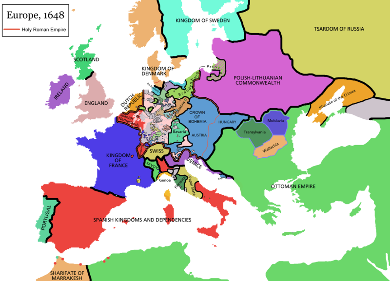
فائل:Europe map 1648.PNG
ڏيک

هن پيش-نگاھ جي ماپ: 800*577 پڪزلس. ٻيا تحلل:320*231 پڪزلس | 640*462 پڪزلس | 1,024*739 پڪزلس | 1,280*924 پڪزلس | 1,894*1,367 پڪزلس
اصلوڪو فائيل (1,894 × 1,367 عڪسلون، فائيل سائيز: 195 KB، MIME ٽائيپ: image/png)
فائيل جي سوانح
ڪنھن بہ تاريخ/وقت تي ٽڙڪ ڪري ڏسندا تہ ان وقت اهو فائيل ڪيئن هو.
| تاريخ/وقت | ٽِڪِلِي | ماپَ | واپرائيندڙ | راءِ | |
|---|---|---|---|---|---|
| هاڻوڪو نسخو | 09:44, 14 اپريل 2021 |  | 1,894 × 1,367 (195 KB) | Tenan | Reverted to version as of 16:09, 12 October 2017 (UTC) See discussion |
| 10:47, 9 مارچ 2021 |  | 1,894 × 1,367 (210 KB) | TTBCamh | Reverted to version as of 17:18, 20 September 2018 (UTC). I don't know why Raderich is saying this is an arbitrary change—Catalonia was under the possession of the French king in 1648, following the Catalan Revolt of 1640. This map is correct and the previous one is incorrect. | |
| 12:12, 25 سيپٽمبر 2018 |  | 1,894 × 1,367 (195 KB) | Raderich | Reverted to version as of 21:15, 18 September 2018 (UTC) Undone arbitrary changes. Revert to correct map as uploaded by its creator Roke~commonswiki | |
| 17:18, 20 سيپٽمبر 2018 |  | 1,894 × 1,367 (210 KB) | AmbroiseL | The Catalan counties were French since they proclaimed Louis XIV of France as their king. They wanted to be French in order not to obey the king of Spain anymore. Courland was a quite free vassal state of Poland. The reverted version doesn't show it. The reverted version also doesn't show the Venetian islands in the Adriatic Sea, and the Algerian towns that France occupied. Hence, I re-revert to the more precise version. | |
| 21:15, 18 سيپٽمبر 2018 |  | 1,894 × 1,367 (195 KB) | Raderich | Reverted to version as of 16:09, 12 October 2017 (UTC) | |
| 10:45, 19 جُولاءِ 2018 |  | 1,894 × 1,367 (210 KB) | AmbroiseL | Reverted to version as of 12:06, 20 January 2017 (UTC) — reverted to the version with fixed names, my mistake | |
| 10:37, 19 جُولاءِ 2018 |  | 1,894 × 1,367 (150 KB) | AmbroiseL | Reverted to version as of 10:33, 24 September 2016 (UTC) | |
| 16:09, 12 آڪٽوبر 2017 |  | 1,894 × 1,367 (195 KB) | 力 | Reverted to version as of 12:42, 9 September 2016 (UTC) why is Catalonia French? Not shown as such on File:Europe_1648_westphal_1884.jpg | |
| 12:06, 20 جنوري 2017 |  | 1,894 × 1,367 (210 KB) | Fakirbakir | Names of Austria, Bohemia and Hungary are fixed. | |
| 10:33, 24 سيپٽمبر 2016 |  | 1,894 × 1,367 (150 KB) | AmbroiseL | Adjunction of polish-lithuanian vassal state of Courland |
ڳنڍڻا
ڪي بہ صفحا ناھن جيڪي ھن فائيل کي استعمال ڪندا ھجن.
فائيل جو ٻين وڪيز تي استعمال
ھيٺيون وڪيز بہ ھيءُ فائيل استعمال ڪن ٿيون:
- als.wikipedia.org تي استعمال
- an.wikipedia.org تي استعمال
- ar.wikipedia.org تي استعمال
- ast.wikipedia.org تي استعمال
- azb.wikipedia.org تي استعمال
- bat-smg.wikipedia.org تي استعمال
- bg.wikipedia.org تي استعمال
- bn.wikipedia.org تي استعمال
- bn.wikibooks.org تي استعمال
- br.wikipedia.org تي استعمال
- bs.wikipedia.org تي استعمال
- ca.wikipedia.org تي استعمال
- Sacre Imperi Romanogermànic
- Dinastia dels Habsburg
- Història d'Europa
- Lluís XIV de França
- Guerra dels Trenta Anys
- Pau de Westfàlia
- Leopold I del Sacre Imperi Romanogermànic
- Guerra dels Vuitanta Anys
- Neollatí
- Antic Règim
- Tractat de Karlowitz
- Setge de Viena (1683)
- Guerra franco-espanyola (1635-1659)
- Gran Guerra Turca
- cs.wikipedia.org تي استعمال
- cy.wikipedia.org تي استعمال
- da.wikipedia.org تي استعمال
- de.wikipedia.org تي استعمال
- de.wikibooks.org تي استعمال
- el.wikipedia.org تي استعمال
- en.wikipedia.org تي استعمال
ھن فائيل جو وڌيڪ گلوبل استعمال ڏسو.


