
فائل:The Village Pound - geograph.org.uk - 1533684.jpg
The_Village_Pound_-_geograph.org.uk_-_1533684.jpg (640 × 480 عڪسلون، فائيل سائيز: 112 KB، MIME ٽائيپ: image/jpeg)
تَتُ
| تشريح |
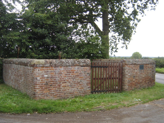
English: The Village Pound, North Elmham, Norfolk. The most common use was to hold stray animals, cattle, sheep, pigs, etc. They were driven into the pound and kept there at the expense of the owner, until such time as he paid the fine, the amount claimed by the 'impounder' (the person onto whose land they had strayed on) for the damage done and the fee to the pound keeper, for feeding and watering them.
If not claimed within three weeks, the animals were driven to the nearest market and sold, the proceeds going to the impounder and the pound-keeper. A clever form of receipt was sometimes used. The person who found the animals on his land cut a stick and made notches, one for every beast, and then split the stick down the centre of the notches so that half of each notch appeared on each stick; one half he kept, the other he gave to the pound-keeper. When the owner came to redeem his animals and had paid for the damage done, the impounder gave him his half stick. He took this to the pound-keeper, and if the two pieces tallied, it proved he had paid, and his beasts were freed. Hence the word 'Tally-stick' and the pound-keeper being referred to as 'The Tallyman'. |
| تاريخ | |
| ذريعو | From geograph.org.uk |
| ليکڪ | John Wernham |
| انتساب (required by the license) | John Wernham / The Village Pound / |
| Camera location | | View this and other nearby images on: OpenStreetMap |
|---|
_heading:315.00&language=sd)
| Object location | | View this and other nearby images on: OpenStreetMap |
|---|
_heading:315.00&language=sd)
لائيسنسڪاري

|
This image was taken from the Geograph project collection. See this photograph's page on the Geograph website for the photographer's contact details. The copyright on this image is owned by John Wernham and is licensed for reuse under the Creative Commons Attribution-ShareAlike 2.0 license.
|
- توھان آزاد آھيو:
- ونڊڻ لاءِ – اھو ڪم نقل ڪرڻ، ورڇڻ، ۽ پارمڪارڻ
- جڳلبندي ڪرڻ – ڪم اختيار ڪرڻ لاءِ
- ھيٺين شرطن تي:
- انتساب – توهان لازماً مناسب انتساب ڏيو، اجازتنامي ڏانھن ڳنڍڻو مھيا ڪريو، ۽ جيڪڏھن ڪي تبديليون ڪيون ويون ھجن تہ انھن جي نشاندھي ڪريو. توهان اهو ڪري سگهو ٿا ڪنھن بہ معقول طريقي سان، پر ڪنھن بہ اھڙي طريقي سان نہ جيڪو ڏسي تہ اجازتنامو ڏيندڙ توهان جي يا توهان جي استعمال جي توثيق ڪري ٿو.
- ھڪجھڙي ڀاڱيداري – جيڪڏھن توھان ٻيھر ملاوٽ، بدلاءُ، يا مواد تي اڏاوت ڪريو ٿا، توھان کي لازماً پنھنجون ڀاڱيداريون ساڳي يا موافق اجازتنامي جھڙو اصل جو ھيو، ھيٺ ٻيھر-ورھائڻ گهرجن.
فائيل جي سوانح
ڪنھن بہ تاريخ/وقت تي ٽڙڪ ڪري ڏسندا تہ ان وقت اهو فائيل ڪيئن هو.
| تاريخ/وقت | آڱوٺي ننھن | ماپَ | واپرائيندڙ | راءِ | |
|---|---|---|---|---|---|
| موجود نسخو | 07:52, 3 مارچ 2011 | | 640 × 480 (112 KB) | GeographBot | == {{int:filedesc}} == {{Information |description={{en|1=The Village Pound The most common use was to hold stray animals, cattle, sheep, pigs, etc. They were driven into the pound and kept there at the expense of the owner, until such time as he pai |
ڳنڍڻا
هن فائيل سان هيٺيان صفحا ڳنڍيل آهن.
گلوبل فائيل جو استعمال
ھيٺيون وڪيز بہ ھيءُ فائيل استعمال ڪن ٿيون:
- en.wikipedia.org تي استعمال
- ru.wikipedia.org تي استعمال
- www.wikidata.org تي استعمال