
فائل:Star Trail above Beccles - geograph.org.uk - 1855505.jpg
اڃان سنھو تحلل ميسر ناھي.
Star_Trail_above_Beccles_-_geograph.org.uk_-_1855505.jpg (800 × 496 عڪسلون، فائيل سائيز: 100 KB، MIME ٽائيپ: image/jpeg)
تَتُ
| تشريح |
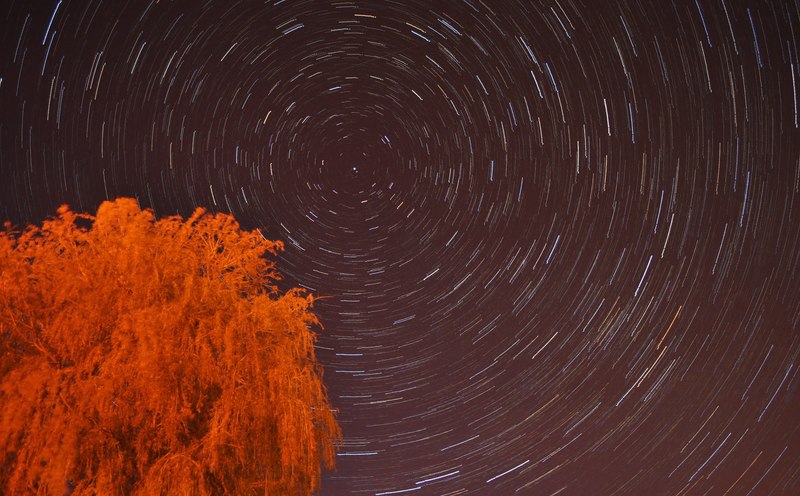
English: Star Trail above Beccles, near to Gillingham, Norfolk, Great Britain.
My last trail (image) was taken in an area with large skies and less light pollution. However I decided to venture out for a little while at Beccles Quay near to midnight and try a star trail here. The street lights highlighted the tree to make it look as if it were dead! However, I can inform you it is green and alive in real life TM4291 : Beccles Quay. I had learnt from last time and brought a stopwatch, meaning even pictures of the same quailty. Twenty photos one and a half minutes long stitched together to give this effect. The faint streak above Polaris (the centre star) is a plane, sadly not a meteor. |
| تاريخ | |
| ذريعو | From geograph.org.uk; transferred by User:Rubberstamp using geograph_org2commons. |
| ليکڪ | Ashley Dace |
| اجازت (ھن فائيل کي وَراستعمال ڪندي) |
Creative Commons Attribution Share-alike license 2.0 |
| Camera location | | View this and other nearby images on: OpenStreetMap |
|---|
| Object location | | View this and other nearby images on: OpenStreetMap |
|---|
_region:GB-GBN_heading:337.00&language=sd)
لائيسنسڪاري

|
This image was taken from the Geograph project collection. See this photograph's page on the Geograph website for the photographer's contact details. The copyright on this image is owned by Ashley Dace and is licensed for reuse under the Creative Commons Attribution-ShareAlike 2.0 license.
|
This file is licensed under the Creative Commons Attribution-Share Alike 2.0 Generic license.
انتساب: Ashley Dace
- توھان آزاد آھيو:
- ونڊڻ لاءِ – اھو ڪم نقل ڪرڻ، ورڇڻ، ۽ پارمڪارڻ
- جڳلبندي ڪرڻ – ڪم اختيار ڪرڻ لاءِ
- ھيٺين شرطن تي:
- انتساب – توهان لازماً مناسب انتساب ڏيو، اجازتنامي ڏانھن ڳنڍڻو مھيا ڪريو، ۽ جيڪڏھن ڪي تبديليون ڪيون ويون ھجن تہ انھن جي نشاندھي ڪريو. توهان اهو ڪري سگهو ٿا ڪنھن بہ معقول طريقي سان، پر ڪنھن بہ اھڙي طريقي سان نہ جيڪو ڏسي تہ اجازتنامو ڏيندڙ توهان جي يا توهان جي استعمال جي توثيق ڪري ٿو.
- ھڪجھڙي ڀاڱيداري – جيڪڏھن توھان ٻيھر ملاوٽ، بدلاءُ، يا مواد تي اڏاوت ڪريو ٿا، توھان کي لازماً پنھنجون ڀاڱيداريون ساڳي يا موافق اجازتنامي جھڙو اصل جو ھيو، ھيٺ ٻيھر-ورھائڻ گهرجن.
فائيل جي سوانح
ڪنھن بہ تاريخ/وقت تي ٽڙڪ ڪري ڏسندا تہ ان وقت اهو فائيل ڪيئن هو.
| تاريخ/وقت | آڱوٺي ننھن | ماپَ | واپرائيندڙ | راءِ | |
|---|---|---|---|---|---|
| موجود نسخو | 14:36, 27 جُولاءِ 2010 | | 800 × 496 (100 KB) | File Upload Bot (Magnus Manske) | == {{int:filedesc}} == {{Information |Description={{en|1=Star Trail above Beccles, near to Gillingham, Norfolk, Great Britain. My last trail (<span class="nowrap"><a title="http://www.geograph.org.uk/photo/1852095)" rel="nofollow" href="http://www.geograp |
ڳنڍڻا
هن فائيل سان هيٺيان صفحا ڳنڍيل آهن.
گلوبل فائيل جو استعمال
ھيٺيون وڪيز بہ ھيءُ فائيل استعمال ڪن ٿيون:
- af.wikipedia.org تي استعمال
- bh.wikipedia.org تي استعمال
- ce.wikipedia.org تي استعمال
- cs.wikipedia.org تي استعمال
- en.wikipedia.org تي استعمال
- en.wikibooks.org تي استعمال
- eu.wikipedia.org تي استعمال
- fa.wikipedia.org تي استعمال
- hi.wikipedia.org تي استعمال
- is.wikipedia.org تي استعمال
- ka.wikipedia.org تي استعمال
- kk.wikipedia.org تي استعمال
- ko.wikipedia.org تي استعمال
- mn.wikipedia.org تي استعمال
- ms.wikipedia.org تي استعمال
- nl.wiktionary.org تي استعمال
- pl.wikipedia.org تي استعمال
- ru.wikipedia.org تي استعمال
- sq.wikipedia.org تي استعمال
- sr.wikipedia.org تي استعمال
- sw.wikipedia.org تي استعمال
- uk.wikipedia.org تي استعمال
- vi.wikipedia.org تي استعمال