
فائل:Political map of Canada.svg

Size of this PNG preview of this SVG file: 736*599 پڪزلس. ٻيا تحلل:295*240 پڪزلس | 590*480 پڪزلس | 943*768 پڪزلس | 1,258*1,024 پڪزلس | 2,516*2,048 پڪزلس | 1,130*920 پڪزلس
اصلوڪو فائيل (ايسويجي فائيل، اٽڪل 1,130 × 920 عڪسلون، فائيل سائيز: 272 KB)
تَتُ
| تشريح |
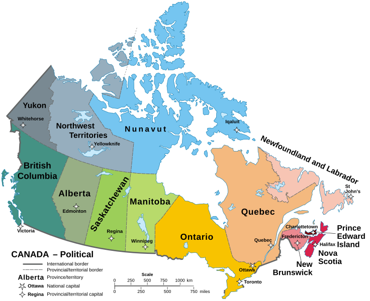
English: A map of Canada in its Provinces and territories Català: Mapa de les províncies i territoris del Canadà. |
||
| تاريخ | |||
| ذريعو | Localisation Manitoba.svg | ||
| ليکڪ | Hogweard | ||
| اجازت (ھن فائيل کي وَراستعمال ڪندي) |
|
||
| Other versions |
Carte Politique du Canada.svg File:Political map of Canada.svg has 1 translations.
|


|
This SVG file contains embedded text that can be translated into your language, using any capable SVG editor, text editor or the SVG Translate tool. For more information see: About translating SVG files. |
فائيل جي سوانح
ڪنھن بہ تاريخ/وقت تي ٽڙڪ ڪري ڏسندا تہ ان وقت اهو فائيل ڪيئن هو.
| تاريخ/وقت | آڱوٺي ننھن | ماپَ | واپرائيندڙ | راءِ | |
|---|---|---|---|---|---|
| موجود نسخو | 11:58, 22 سيپٽمبر 2023 | | 1,130 × 920 (272 KB) | Lalpino | File uploaded using svgtranslate tool (https://svgtranslate.toolforge.org/). Added translation for ca. |
| 14:58, 14 آڪٽوبر 2022 |  | 1,130 × 920 (256 KB) | Enkhsaihan2005 | File uploaded using svgtranslate tool (https://svgtranslate.toolforge.org/). Added translation for mn. | |
| 00:43, 21 جُونِ 2022 |  | 1,130 × 920 (211 KB) | -tynjee | File uploaded using svgtranslate tool (https://svgtranslate.toolforge.org/). Added translation for vi. | |
| 02:21, 23 آگسٽ 2021 |  | 1,130 × 920 (199 KB) | Praça de Maio | File uploaded using svgtranslate tool (https://svgtranslate.toolforge.org/). Added translation for tr. | |
| 01:59, 29 جنوري 2021 |  | 1,130 × 920 (161 KB) | Allice Hunter | Reverted to version as of 11:37, 19 October 2020 (UTC) | |
| 01:59, 29 جنوري 2021 |  | 512 × 424 (95 KB) | Allice Hunter | Largest cities | |
| 11:37, 19 آڪٽوبر 2020 |  | 1,130 × 920 (161 KB) | Hogweard | Fixed N&L label | |
| 08:48, 18 آڪٽوبر 2020 |  | 1,130 × 920 (161 KB) | Hogweard | {{Information |description=A map of Canada in its Provinces and territories |date=2020-10-18 |source={{f|Localisation_Manitoba.svg}} |author={{u|Hogweard}} |permission={{PD-self}} |other versions={{f|Carte Politique du Canada.svg}} }} Category:SVG maps of Canada Category:English language maps of Canada Category:Political maps of Canada |
ڳنڍڻا
هن فائيل سان هيٺيان صفحا ڳنڍيل آهن.
گلوبل فائيل جو استعمال
ھيٺيون وڪيز بہ ھيءُ فائيل استعمال ڪن ٿيون:
- as.wikipedia.org تي استعمال
- azb.wikipedia.org تي استعمال
- bh.wikipedia.org تي استعمال
- br.wikipedia.org تي استعمال
- ca.wikipedia.org تي استعمال
- el.wikipedia.org تي استعمال
- en.wikipedia.org تي استعمال
- io.wikipedia.org تي استعمال
- ku.wikipedia.org تي استعمال
- mdf.wikipedia.org تي استعمال
- mn.wikipedia.org تي استعمال
- my.wikipedia.org تي استعمال
- pa.wikipedia.org تي استعمال
- sq.wikipedia.org تي استعمال
- sr.wikipedia.org تي استعمال
- tl.wikipedia.org تي استعمال
- to.wikipedia.org تي استعمال
- tr.wikipedia.org تي استعمال
- uk.wikipedia.org تي استعمال
- vi.wikipedia.org تي استعمال