
فائل:Oceans and seas boundaries map-en.svg

Size of this PNG preview of this SVG file: 800*406 پڪزلس. ٻيا تحلل:320*162 پڪزلس | 640*325 پڪزلس | 1,024*519 پڪزلس | 1,280*649 پڪزلس | 2,560*1,299 پڪزلس | 4,000*2,029 پڪزلس
اصلوڪو فائيل (ايسويجي فائيل، اٽڪل 4,000 × 2,029 عڪسلون، فائيل سائيز: 1.39 MB)
تَتُ
| تشريح |
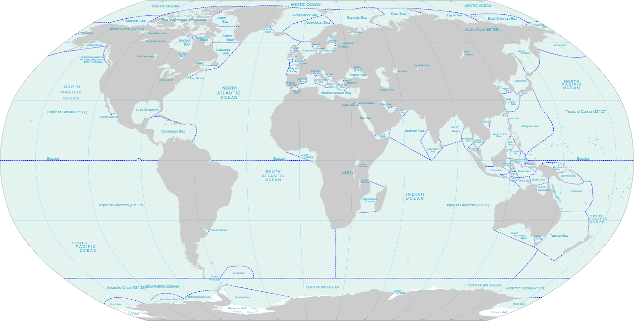
English: World map of oceans and seas : English version |
| تاريخ | (UTC) |
| ذريعو |
Own work using:
|
| ليکڪ | |
| Other versions | Turkish version, French version |
| This is a retouched picture, which means that it has been digitally altered from its original version. Modifications: Translated remaining French labels, fixed some English labels, added missing sea and lake names, added missing lake, refactored text styling of some labels to match the rest, fixed rainbow of colors assigned to random islands, added missing Malta and Bermuda islands. The original can be viewed here: Oceans and seas boundaries map-en.svg:
|
I, the copyright holder of this work, hereby publish it under the following licenses:
This file is licensed under the Creative Commons Attribution-Share Alike 3.0 Unported, 2.5 Generic, 2.0 Generic and 1.0 Generic license.
- توھان آزاد آھيو:
- ونڊڻ لاءِ – اھو ڪم نقل ڪرڻ، ورڇڻ، ۽ پارمڪارڻ
- جڳلبندي ڪرڻ – ڪم اختيار ڪرڻ لاءِ
- ھيٺين شرطن تي:
- انتساب – توهان لازماً مناسب انتساب ڏيو، اجازتنامي ڏانھن ڳنڍڻو مھيا ڪريو، ۽ جيڪڏھن ڪي تبديليون ڪيون ويون ھجن تہ انھن جي نشاندھي ڪريو. توهان اهو ڪري سگهو ٿا ڪنھن بہ معقول طريقي سان، پر ڪنھن بہ اھڙي طريقي سان نہ جيڪو ڏسي تہ اجازتنامو ڏيندڙ توهان جي يا توهان جي استعمال جي توثيق ڪري ٿو.
- ھڪجھڙي ڀاڱيداري – جيڪڏھن توھان ٻيھر ملاوٽ، بدلاءُ، يا مواد تي اڏاوت ڪريو ٿا، توھان کي لازماً پنھنجون ڀاڱيداريون ساڳي يا موافق اجازتنامي جھڙو اصل جو ھيو، ھيٺ ٻيھر-ورھائڻ گهرجن.

|
ھن دستاويز کي جي.اين.يو مفت دستاويزسازي اجازتنامي ، مفت سافٽويئر فائونڊيشن پاران ڇاپيل ورزن 1.2 يا ٻي ڪنھن بعد واري ورزن؛ جنھن ۾ نہ انويريئينٽ ڀاڱا، ۽ نہ فونٽ-ڪور متنَ، ۽ نہ بيڪ-ڪور متنَ شامل آھن، جي شرطن ھيٺ نقل ڪرڻ، ورھائن ۽/يا بدلائڻ جي اجازت ڏني وئي آھي. اجازتنامي جو نقل [[c:Commons:GNU Free Documentation License, version 1.2 | جي.اين.يو مفت دستاويزسازي اجازتنامو]] نالي ڀاڱي ۾ ڏنل آھي. |
توھان پنھنجي پسند جو اجازتنامو چونڊي سگهو ٿا.
Original upload log
This image is a derivative work of the following images:
- File:Oceans and seas boundaries map-fr.svg licensed with Cc-by-sa-3.0,2.5,2.0,1.0, GFDL
- 2021-04-05T01:32:50Z Dziban303 2753x1538 (1276318 Bytes) == {{int:filedesc}} == {{Information |Description={{en|World map of oceans and seas : English version}} |Source={{Derived from|Oceans and seas boundaries map-en.svg|display=50}} |Date=2021-04-05 01:09 (UTC) |Author=* [[:File:
- 2021-04-04T21:12:48Z Dziban303 2753x1538 (1268270 Bytes) == {{int:filedesc}} == {{Information |Description=English: World map of oceans and seas : English version|Source={{Derived from|Oceans and seas boundaries map-en.svg|display=50}} |Date=2021-04-04 21:10 (UTC) |Author=* [[:File:
- 2011-02-13T11:57:29Z Jugger90 2753x1538 (1263323 Bytes) {{Information |Description={{en|World map of oceans and seas : french version}} {{fr|Carte des océans et des mers du monde : version vide}} |Source=*[[:File:Oceans_and_seas_boundaries_map-fr.svg|]] |Date=2011-02-13 11:56 (UT
Uploaded with derivativeFX
فائيل جي سوانح
ڪنھن بہ تاريخ/وقت تي ٽڙڪ ڪري ڏسندا تہ ان وقت اهو فائيل ڪيئن هو.
| تاريخ/وقت | آڱوٺي ننھن | ماپَ | واپرائيندڙ | راءِ | |
|---|---|---|---|---|---|
| موجود نسخو | 14:11, 11 جُونِ 2021 | | 4,000 × 2,029 (1.39 MB) | Ibrahim Muizzuddin | Edit toponymy, resize |
| 13:35, 11 جُونِ 2021 |  | 2,753 × 1,396 (1.22 MB) | Ibrahim Muizzuddin | Fit image | |
| 02:13, 5 اپريل 2021 |  | 2,753 × 1,538 (1.22 MB) | Dziban303 | == {{int:filedesc}} == {{Information |Description={{en|World map of oceans and seas — English version}} |Source={{Derived from|Oceans and seas boundaries map-en.svg|display=50}} |Date=2021-04-05 02:11 (UTC) |Author=* File:Oceans and seas boundaries map-en.svg: *Oceans_and_seas_boundaries_map-fr.svg: Pinpin * derivative work: Jugger90 ([[User talk:Jugger90|<span cla... | |
| 01:32, 5 اپريل 2021 |  | 2,753 × 1,538 (1.22 MB) | Dziban303 | == {{int:filedesc}} == {{Information |Description={{en|World map of oceans and seas : English version}} |Source={{Derived from|Oceans and seas boundaries map-en.svg|display=50}} |Date=2021-04-05 01:09 (UTC) |Author=* File:Oceans and seas boundaries map-en.svg: *Oceans_and_seas_boundaries_map-fr.svg: Pinpin *derivative work: Jugger90 ([[User talk:Jugger90|<span clas... | |
| 21:12, 4 اپريل 2021 |  | 2,753 × 1,538 (1.21 MB) | Dziban303 | == {{int:filedesc}} == {{Information |Description={{en|World map of oceans and seas : English version}} |Source={{Derived from|Oceans and seas boundaries map-en.svg|display=50}} |Date=2021-04-04 21:10 (UTC) |Author=* File:Oceans and seas boundaries map-en.svg: *Oceans_and_seas_boundaries_map-fr.svg: Pinpin *derivative work: Jugger90 ([[User talk:Jugger90|<span clas... | |
| 11:57, 13 فيبروري 2011 |  | 2,753 × 1,538 (1.2 MB) | Jugger90 | {{Information |Description={{en|World map of oceans and seas : french version}} {{fr|Carte des océans et des mers du monde : version vide}} |Source=*File:Oceans_and_seas_boundaries_map-fr.svg |Date=2011-02-13 11:56 (UTC) |Author=*[[:File:Oceans_and |
ڳنڍڻا
هن فائيل سان هيٺيان صفحا ڳنڍيل آهن.
گلوبل فائيل جو استعمال
ھيٺيون وڪيز بہ ھيءُ فائيل استعمال ڪن ٿيون:
- ar.wikipedia.org تي استعمال
- ast.wikipedia.org تي استعمال
- bh.wikipedia.org تي استعمال
- blk.wikipedia.org تي استعمال
- bs.wikipedia.org تي استعمال
- ceb.wikipedia.org تي استعمال
- da.wikipedia.org تي استعمال
- de.wikipedia.org تي استعمال
- el.wikipedia.org تي استعمال
- en.wikipedia.org تي استعمال
- eo.wikipedia.org تي استعمال
- es.wikipedia.org تي استعمال
- eu.wikipedia.org تي استعمال
- fa.wikipedia.org تي استعمال
- fi.wikipedia.org تي استعمال
- fr.wikipedia.org تي استعمال
- id.wikipedia.org تي استعمال
- ilo.wikipedia.org تي استعمال
- it.wikipedia.org تي استعمال
- ka.wikipedia.org تي استعمال
- kn.wikipedia.org تي استعمال
- mk.wikipedia.org تي استعمال
- mn.wikipedia.org تي استعمال
- mr.wikipedia.org تي استعمال
- ms.wikipedia.org تي استعمال
- ro.wikipedia.org تي استعمال
- ru.wikipedia.org تي استعمال
- sh.wikipedia.org تي استعمال
- sl.wikipedia.org تي استعمال
- sn.wikipedia.org تي استعمال
- sv.wikipedia.org تي استعمال
- th.wikipedia.org تي استعمال
- tl.wikipedia.org تي استعمال
- ur.wikipedia.org تي استعمال
- vi.wikipedia.org تي استعمال
- zh.wikipedia.org تي استعمال