
فائل:Irma 2017-09-05 1706Z.jpg
هن پيش-نگاھ جي ماپ: 450*600 پڪزلس. ٻيا تحلل:180*240 پڪزلس | 360*480 پڪزلس | 576*768 پڪزلس | 768*1,024 پڪزلس | 1,536*2,048 پڪزلس | 4,950*6,600 پڪزلس
اصلوڪو فائيل (4,950 × 6,600 عڪسلون، فائيل سائيز: 8.39 MB، MIME ٽائيپ: image/jpeg)
تَتُ
| تشريح |
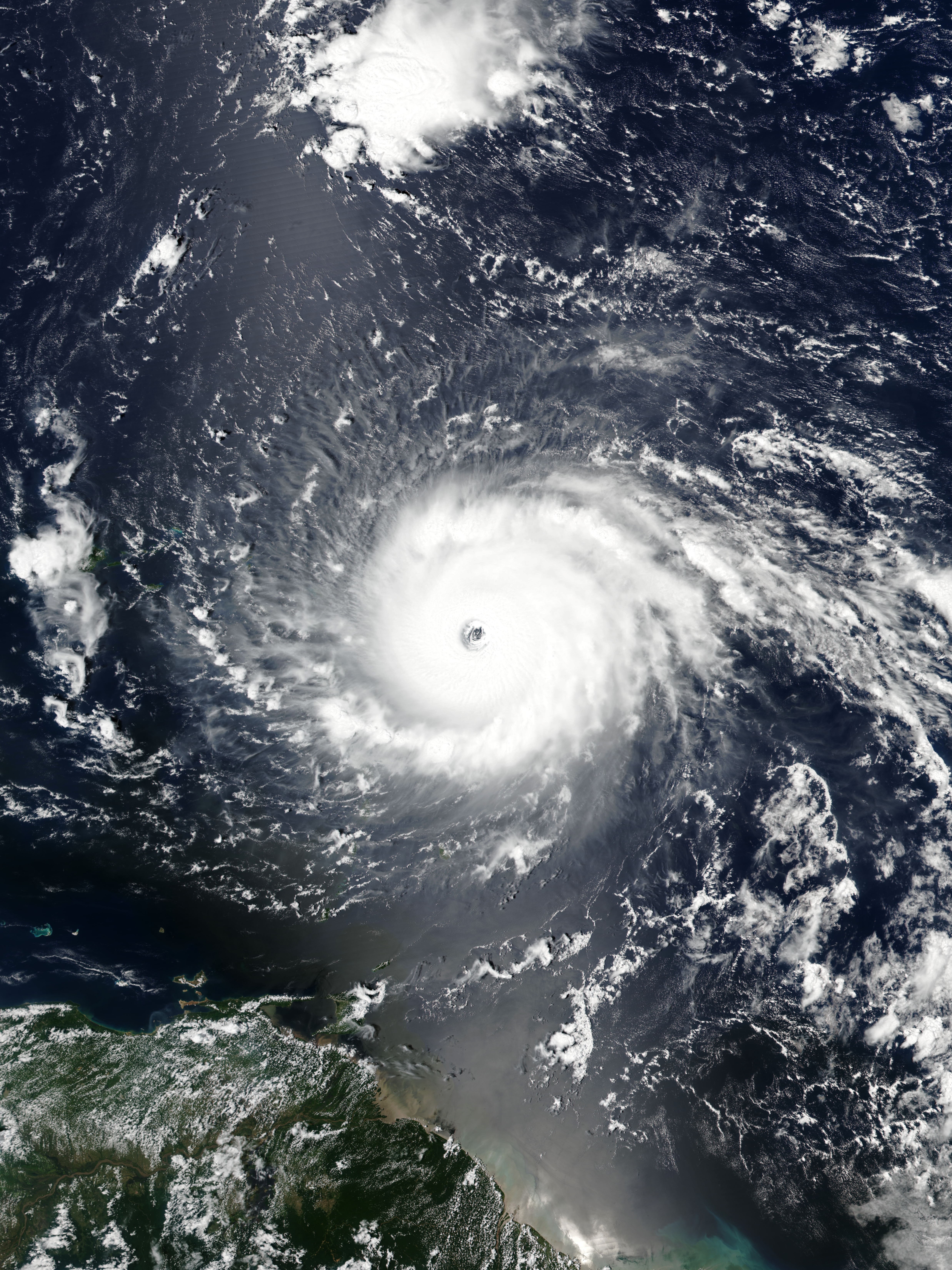
English: Hurricane Irma approaching the Leeward Islands at peak intensity on September 5, 2017 as the third most intense Atlantic hurricane on record in terms of sustained winds. |
| تاريخ | |
| ذريعو | EOSDIS Worldview |
| ليکڪ | VIIRS image captured by NOAA’s Suomi NPP satellite |
| Camera location | | View this and other nearby images on: OpenStreetMap |
|---|
لائيسنسڪاري
| This file is in the public domain in the United States because it was solely created by NASA. NASA copyright policy states that "NASA material is not protected by copyright unless noted". (See Template:PD-USGov, NASA copyright policy page or JPL Image Use Policy.) | ||
 |
Warnings:
|
فائيل جي سوانح
ڪنھن بہ تاريخ/وقت تي ٽڙڪ ڪري ڏسندا تہ ان وقت اهو فائيل ڪيئن هو.
| تاريخ/وقت | آڱوٺي ننھن | ماپَ | واپرائيندڙ | راءِ | |
|---|---|---|---|---|---|
| موجود نسخو | 01:21, 15 مَئي 2021 | | 4,950 × 6,600 (8.39 MB) | Supportstorm | Reverted to version as of 21:19, 5 September 2017 (UTC) |
| 00:12, 15 مَئي 2021 |  | 437 × 452 (89 KB) | Super Cyclonic Storm Corona | Crop a bit. | |
| 21:19, 5 سيپٽمبر 2017 |  | 4,950 × 6,600 (8.39 MB) | Meow | User created page with UploadWizard |
ڳنڍڻا
هن فائيل سان هيٺيان صفحا ڳنڍيل آهن.
گلوبل فائيل جو استعمال
ھيٺيون وڪيز بہ ھيءُ فائيل استعمال ڪن ٿيون:
- ca.wikipedia.org تي استعمال
- cs.wikipedia.org تي استعمال
- en.wikipedia.org تي استعمال
- Portal:Tropical cyclones/Anniversaries/September
- Portal:Tropical cyclones/Anniversaries/September/5
- User:LightandDark2000/My Notable Storms
- Talk:Hurricane Irma/Archive 2
- User:Tfmbty/List of the most intense tropical cyclones since 1979
- User talk:36.82.216.113
- Talk:2018 Atlantic hurricane season/Archive 2
- User talk:82.8.147.67
- es.wikipedia.org تي استعمال
- et.wikipedia.org تي استعمال
- eu.wikipedia.org تي استعمال
- ga.wikipedia.org تي استعمال
- hu.wikipedia.org تي استعمال
- hy.wikipedia.org تي استعمال
- pt.wikipedia.org تي استعمال
- ru.wikipedia.org تي استعمال
- sr.wikipedia.org تي استعمال
- th.wikipedia.org تي استعمال
- uk.wikipedia.org تي استعمال
- uz.wikipedia.org تي استعمال
- www.wikidata.org تي استعمال
- zh.wikipedia.org تي استعمال