
فائل:Gwadar satellite view showing island created by 2013 earthquake.jpg

هن پيش-نگاھ جي ماپ: 600*600 پڪزلس. ٻيا تحلل:240*240 پڪزلس | 480*480 پڪزلس | 768*768 پڪزلس | 1,024*1,024 پڪزلس | 2,000*2,000 پڪزلس
اصلوڪو فائيل (2,000 × 2,000 عڪسلون، فائيل سائيز: 861 KB، MIME ٽائيپ: image/jpeg)
تَتُ
| تشريح |
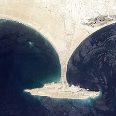
English: Zalzala Jazeera (Earthquake Island) appears in the upper left quadrant of this image of Gwadar, Pakistan.
On September 26, 2013, the Advanced Land Imager (ALI) on NASA’s Earth Observing-1 (EO-1) satellite captured the top image of that new island, which sits roughly one kilometer (0.6 miles) offshore. Likely a “mud volcano,” the island rose from the seafloor near Gwadar on September 24, shortly after the earthquake struck about 380 kilometers (230 miles) inland. File:Gwadar satellite view.jpg, acquired by the Operational Land Imager on the Landsat 8 satellite, shows the same area on April 17, 2013. In the satellite images, lighter shades of green and tan in the water reveal shallow seafloor or suspended sediment. The water depth around the new island is roughly 15 to 20 meters, according to marine geologist Asif Inam of Pakistan’s National Institute of Oceanography. “The floor in that area is generally flat, but the gradient in this area changes quite abruptly,” Inam said. The top image from ALI is also clear enough to show the parallel ripples of waves marching toward the shore. |
| تاريخ | |
| ذريعو | http://earthobservatory.nasa.gov/NaturalHazards/view.php?id=82146 |
| ليکڪ | NASA |
| Other versions |
  |
| Camera location | | View this and other nearby images on: OpenStreetMap |
|---|
لائيسنسڪاري
| This file is in the public domain in the United States because it was solely created by NASA. NASA copyright policy states that "NASA material is not protected by copyright unless noted". (See Template:PD-USGov, NASA copyright policy page or JPL Image Use Policy.) | ||
 |
Warnings:
|
فائيل جي سوانح
ڪنھن بہ تاريخ/وقت تي ٽڙڪ ڪري ڏسندا تہ ان وقت اهو فائيل ڪيئن هو.
| تاريخ/وقت | آڱوٺي ننھن | ماپَ | واپرائيندڙ | راءِ | |
|---|---|---|---|---|---|
| موجود نسخو | 01:04, 28 سيپٽمبر 2013 | | 2,000 × 2,000 (861 KB) | Ke4roh | User created page with UploadWizard |
ڳنڍڻا
هن فائيل سان هيٺيان صفحا ڳنڍيل آهن.
گلوبل فائيل جو استعمال
ھيٺيون وڪيز بہ ھيءُ فائيل استعمال ڪن ٿيون:
- ar.wikipedia.org تي استعمال
- az.wikipedia.org تي استعمال
- de.wikipedia.org تي استعمال
- es.wikipedia.org تي استعمال
- fi.wikipedia.org تي استعمال
- fr.wikipedia.org تي استعمال
- it.wikipedia.org تي استعمال
- ru.wikipedia.org تي استعمال
- tr.wikipedia.org تي استعمال