مواد ڏانھن هلو

فائل:Gibraltar map-en.svg

صفحي جو مواد ٻين ٻولين ۾ سپورٽ نہ ڪيو ويو آھي.
کليل ڄاڻ چيڪلي، وڪيپيڊيا مان

اصلوڪو فائيل (ايسويجي فائيل، اٽڪل 2,020 × 3,140 عڪسلون، فائيل سائيز: 289 KB)

ھي فائيل وڪيميڊيا العام مان آھي ۽ ٻين رٿائن پاران پڻ استعمال ٿي سگهي ٿو. تشريح انجي [فائيل جي تشريحي صفحي] ھيٺان ڏنل آھي.

عڪس of the year
عڪس of the year
Featured عڪس

وڪيميڊيا ڪامنز

This file was a candidate in Picture of the Year 2007.
This is a featured picture on Wikimedia Commons (Featured pictures) and is considered one of the finest images. See its nomination here.

If you have an image of similar quality that can be published under a suitable copyright license, be sure to upload it, tag it, and nominate it.

تَتُ

Camera location٣٦° ٠٨′ ٠٠″ N, ٥° ٢١′ ٠٠″ W Kartographer map based on OpenStreetMap.View this and other nearby images on: OpenStreetMapinfo
تشريح
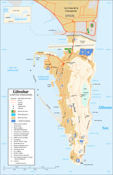
Čeština: Mapa ostrova Gibraltar v angličtině.
English: Map in English of Gibraltar.
Français : * Sujet : Carte en anglais de Gibraltar ;
  • Sources : Création personnelle ;
  • Carte créée à partir de captures d'écran d'images satellite de Google Earth d'un point de vue placé à 1,18 km d'altitude (imagerie disponible de novembre 2007) ;
  • Références complémentaires :
  • Échelle approximative : 1:40 000 (précision : environ 10 m) ;
  • Note : Largeur du tracé des routes proportionnelle à la réalité ;
  • Auteur : Eric Gaba (fr:Sting) ;
  • Date : Novembre 2007.
Português: Mapa (em Inglês) de Gibraltar.
تاريخ
ذريعو Own work ;
Map created using screenshots of Google Earth satellite imagery from a point of view located at 1.18 km of altitude (available imagery of November 2007) ;
Other references :
* CIA map ;
* Gibnet map ;
* U.K. MoD map
Locator map : Image:Blank_map_of_South_Europe_and_North_Africa.svg (modified) created by Historicair ;
Approximate scale : 1:40,000 (accuracy : about 10 m)
Note : The roads width is proportional to reality
ليکڪ Eric Gaba (Sting)
اجازت
(ھن فائيل کي وَراستعمال ڪندي)
Attribution and Share-Alike required
Other versions

[سنواريو]

Disputed isthmus and land
SVG genesis
InfoField
 
The SVG code is valid.
 
This map was created with Inkscape…important.
 
 This map uses embedded text that can be easily translated using a text editor.

لائيسنسڪاري

I, the copyright holder of this work, hereby publish it under the following licenses:
GNU head ھن دستاويز کي جي.اين.يو مفت دستاويزسازي اجازتنامي ، مفت سافٽويئر فائونڊيشن پاران ڇاپيل ورزن 1.2 يا ٻي ڪنھن بعد واري ورزن؛ جنھن ۾ نہ انويريئينٽ ڀاڱا، ۽ نہ فونٽ-ڪور متنَ، ۽ نہ بيڪ-ڪور متنَ شامل آھن، جي شرطن ھيٺ نقل ڪرڻ، ورھائن ۽/يا بدلائڻ جي اجازت ڏني وئي آھي. اجازتنامي جو نقل [[c:Commons:GNU Free Documentation License, version 1.2 جي.اين.يو مفت دستاويزسازي اجازتنامو]] نالي ڀاڱي ۾ ڏنل آھي.
w:en:Creative Commons
انتساب ھڪجھڙي ڀاڱيداري
This file is licensed under the Creative Commons Attribution-Share Alike 4.0 International, 3.0 Unported, 2.5 Generic, 2.0 Generic and 1.0 Generic license.
توھان آزاد آھيو:
  • ونڊڻ لاءِ – اھو ڪم نقل ڪرڻ، ورڇڻ، ۽ پارمڪارڻ
  • جڳلبندي ڪرڻ – ڪم اختيار ڪرڻ لاءِ
ھيٺين شرطن تي:
  • انتساب – توهان لازماً مناسب انتساب ڏيو، اجازتنامي ڏانھن ڳنڍڻو مھيا ڪريو، ۽ جيڪڏھن ڪي تبديليون ڪيون ويون ھجن تہ انھن جي نشاندھي ڪريو. توهان اهو ڪري سگهو ٿا ڪنھن بہ معقول طريقي سان، پر ڪنھن بہ اھڙي طريقي سان نہ جيڪو ڏسي تہ اجازتنامو ڏيندڙ توهان جي يا توهان جي استعمال جي توثيق ڪري ٿو.
  • ھڪجھڙي ڀاڱيداري – جيڪڏھن توھان ٻيھر ملاوٽ، بدلاءُ، يا مواد تي اڏاوت ڪريو ٿا، توھان کي لازماً پنھنجون ڀاڱيداريون ساڳي يا موافق اجازتنامي جھڙو اصل جو ھيو، ھيٺ ٻيھر-ورھائڻ گهرجن.
توھان پنھنجي پسند جو اجازتنامو چونڊي سگهو ٿا.

عنوان

ھڪ-سٽي وضاحت ڏيو تہ ھي فائيل ڇاکي ٿو ظاھر ڪري

Items portrayed in this file

depicts انگريزي

copyright status انگريزي

copyrighted انگريزي

inception انگريزي

نومبر 2007

36°7'59.999"N, 5°21'0.000"W

media type انگريزي

image/svg+xml

فائيل جي سوانح

ڪنھن بہ تاريخ/وقت تي ٽڙڪ ڪري ڏسندا تہ ان وقت اهو فائيل ڪيئن هو.

تاريخ/وقتٽِڪِلِيماپَواپرائيندڙراءِ
هاڻوڪو نسخو20:10, 21 فيبروري 202020:10, 21 فيبروري 2020 جي نظرثاني لاءِ تصويري نشان2,020 × 3,140 (289 KB)JoKalliauermalformed svg (compare firefox/chrome rendering with librsvg-rendering) actually firefox/chrome were correct, also it looks wrong
06:01, 29 جُونِ 201706:01, 29 جُونِ 2017 جي نظرثاني لاءِ تصويري نشان2,020 × 3,140 (538 KB)Wereldburger758Removal error in file. Valid SVG now.
21:52, 27 آگسٽ 200821:52, 27 آگسٽ 2008 جي نظرثاني لاءِ تصويري نشان2,020 × 3,140 (569 KB)RedCoatRemove "claimed by Spain", completely gratuitous for a map
11:28, 11 ڊسمبر 200711:28, 11 ڊسمبر 2007 جي نظرثاني لاءِ تصويري نشان2,020 × 3,140 (570 KB)StingNotification of the Spanish claims
14:40, 27 نومبر 200714:40, 27 نومبر 2007 جي نظرثاني لاءِ تصويري نشان2,020 × 3,140 (569 KB)StingAdditional names ; up-to-date corrections
21:35, 26 نومبر 200721:35, 26 نومبر 2007 جي نظرثاني لاءِ تصويري نشان2,020 × 3,140 (561 KB)RedCoatHouse of Assembly → Gibraltar Parliament
19:51, 26 نومبر 200719:51, 26 نومبر 2007 جي نظرثاني لاءِ تصويري نشان2,020 × 3,140 (561 KB)Sting+ info
14:12, 26 نومبر 200714:12, 26 نومبر 2007 جي نظرثاني لاءِ تصويري نشان2,020 × 3,140 (561 KB)Sting+ info
13:21, 26 نومبر 200713:21, 26 نومبر 2007 جي نظرثاني لاءِ تصويري نشان2,020 × 3,140 (561 KB)Sting{{Information |Description=Map in English of Gibraltar |Source=Own work ;<br/>Map created using screenshots of Google Earth satellite imagery from a point of view located at 1.18 km of altitude (available image

ڪي بہ صفحا ناھن جيڪي ھن فائيل کي استعمال ڪندا ھجن.

فائيل جو ٻين وڪيز تي استعمال

ھيٺيون وڪيز بہ ھيءُ فائيل استعمال ڪن ٿيون:

اعدادِ اعداد