
فائل:Map Bolivia territorial loss-en.jpg

اڃان سنھو تحلل ميسر ناھي.
Map_Bolivia_territorial_loss-en.jpg (471 × 447 عڪسلون، فائيل سائيز: 56 KB، MIME ٽائيپ: image/jpeg)

|
File:Map Bolivia territorial loss-en.svg is a vector version of this file. It should be used in place of this JPG file when not inferior.
File:Map Bolivia territorial loss-en.jpg → File:Map Bolivia territorial loss-en.svg
For more information, see Help:SVG. |
 |
تَتُ
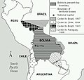
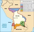
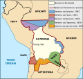
Taken from PDF file: http://lcweb2.loc.gov/frd/cs/bolivia/bo01_05a.pdf Converted by uploader The file is part of the Library of Congress Country Study on Bolivia
Other versions: []
-
 English (JPEG original)
 -
 English
 -
 español
 -
 français
 -
 magyar
 -
 македонски
 -
 српски / srpski


لائيسنسڪاري
This work is in the public domain in the United States because it is a work prepared by an officer or employee of the United States Government as part of that person’s official duties under the terms of Title 17, Chapter 1, Section 105 of the US Code.
Note: This only applies to original works of the Federal Government and not to the work of any individual U.S. state, territory, commonwealth, county, municipality, or any other subdivision. This template also does not apply to postage stamp designs published by the United States Postal Service since 1978. (See § 313.6(C)(1) of Compendium of U.S. Copyright Office Practices). It also does not apply to certain US coins; see The US Mint Terms of Use.
|
 | |
| This file has been identified as being free of known restrictions under copyright law, including all related and neighboring rights. | ||
derivative works
Derivative works of this file: Map Bolivia territorial loss-en.svg
فائيل جي سوانح
ڪنھن بہ تاريخ/وقت تي ٽڙڪ ڪري ڏسندا تہ ان وقت اهو فائيل ڪيئن هو.
| تاريخ/وقت | آڱوٺي ننھن | ماپَ | واپرائيندڙ | راءِ | |
|---|---|---|---|---|---|
| موجود نسخو | 22:10, 24 جنوري 2006 | | 471 × 447 (56 KB) | Bkwillwm | Category:Maps of Bolivia Category:LOC Wikiproject Taken from PDF file: http://lcweb2.loc.gov/frd/cs/bolivia/bo01_05a.pdf Converted by uploader The file is part of the Library of Congress Country Study on Bolivia |
ڳنڍڻا
ڪي بہ صفحا ناھن جيڪي ھن فائيل کي استعمال ڪندا ھجن.
گلوبل فائيل جو استعمال
ھيٺيون وڪيز بہ ھيءُ فائيل استعمال ڪن ٿيون:
- en.wikibooks.org تي استعمال
- es.wikipedia.org تي استعمال
- fr.wikipedia.org تي استعمال