
فائل:Arctic Ocean location map.svg

Size of this PNG preview of this SVG file: 600*599 پڪزلس. ٻيا تحلل:240*240 پڪزلس | 481*480 پڪزلس | 769*768 پڪزلس | 1,025*1,024 پڪزلس | 2,051*2,048 پڪزلس | 709*708 پڪزلس
اصلوڪو فائيل (ايسويجي فائيل، اٽڪل 709 × 708 عڪسلون، فائيل سائيز: 589 KB)
تَتُ
| تشريح |
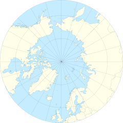
English: Location Map of the Arctic Ocean
|
| تاريخ | |
| ذريعو | ڪم پنھنجايو |
| ليکڪ | Tentotwo |
| Other versions |
|

لائيسنسڪاري
I, the copyright holder of this work, hereby publish it under the following license:
ھي فائيل ڪريئيٽو ڪامنز انتساب-ھڪجھڙي ڀاڱيداري 3.0 انپورٽڊ اجازتنامي ھيٺ اجازتنامو ڏنل آھي.
- توھان آزاد آھيو:
- ونڊڻ لاءِ – اھو ڪم نقل ڪرڻ، ورڇڻ، ۽ پارمڪارڻ
- جڳلبندي ڪرڻ – ڪم اختيار ڪرڻ لاءِ
- ھيٺين شرطن تي:
- انتساب – توهان لازماً مناسب انتساب ڏيو، اجازتنامي ڏانھن ڳنڍڻو مھيا ڪريو، ۽ جيڪڏھن ڪي تبديليون ڪيون ويون ھجن تہ انھن جي نشاندھي ڪريو. توهان اهو ڪري سگهو ٿا ڪنھن بہ معقول طريقي سان، پر ڪنھن بہ اھڙي طريقي سان نہ جيڪو ڏسي تہ اجازتنامو ڏيندڙ توهان جي يا توهان جي استعمال جي توثيق ڪري ٿو.
- ھڪجھڙي ڀاڱيداري – جيڪڏھن توھان ٻيھر ملاوٽ، بدلاءُ، يا مواد تي اڏاوت ڪريو ٿا، توھان کي لازماً پنھنجون ڀاڱيداريون ساڳي يا موافق اجازتنامي جھڙو اصل جو ھيو، ھيٺ ٻيھر-ورھائڻ گهرجن.
Shell script for generating the map using GMT archive copy at the Wayback Machine
#!/bin/sh

# Set common options
PROJECTION=E0.0/90.0/20.0c
REGION=-180/180/50/90
FILENAME=arctic_ocean.ps

# Get Natural Earth datafiles
echo "Downloading datafiles from naturalearthdata.com"
wget -nv -nc \
 http://www.naturalearthdata.com/http//www.naturalearthdata.com/download/50m/physical/50m-coastline.zip\
 http://www.naturalearthdata.com/http//www.naturalearthdata.com/download/50m/physical/50m-land.zip\
 http://www.naturalearthdata.com/http//www.naturalearthdata.com/download/50m/cultural/50m-admin-0-boundary-lines.zip
echo "...done\n"

echo "Inflating archives"
unzip 50m\*.zip
echo "...done\n"

echo "Converting shapefiles to GMT"
ogr2ogr -F GMT 50m_land.gmt 50m_land.shp
ogr2ogr -F GMT 50m_coastline.gmt 50m_coastline.shp
ogr2ogr -F GMT 50m_borders.gmt ne_50m_admin_0_boundary_lines_land.shp
echo "...done\n"

echo "Creating maps"
GMT psxy -m -J$PROJECTION -R$REGION -Bg15 --POLAR_CAP=none --BASEMAP_TYPE=plain --BASEMAP_AXES=WeS 50m_land.gmt -K -G254/254/233 > $FILENAME
GMT psxy -m -J$PROJECTION -R$REGION 50m_coastline.gmt -O -K -W9/120/171  >> $FILENAME
GMT psxy -m -J$PROJECTION -R$REGION 50m_borders.gmt -O -W100/100/100  >> $FILENAME
echo "...done\n"

echo "You can now open $FILENAME in Inkscape to clean up the file and save it as SVG. You should add an ocean coloured background and simplify the graticules using CTRL+L."
فائيل جي سوانح
ڪنھن بہ تاريخ/وقت تي ٽڙڪ ڪري ڏسندا تہ ان وقت اهو فائيل ڪيئن هو.
| تاريخ/وقت | آڱوٺي ننھن | ماپَ | واپرائيندڙ | راءِ | |
|---|---|---|---|---|---|
| موجود نسخو | 11:54, 27 جنوري 2012 | | 709 × 708 (589 KB) | Tentotwo |
ڳنڍڻا
هن فائيل سان هيٺيان صفحا ڳنڍيل آهن.
گلوبل فائيل جو استعمال
ھيٺيون وڪيز بہ ھيءُ فائيل استعمال ڪن ٿيون:
- af.wikipedia.org تي استعمال
- ar.wikipedia.org تي استعمال
- ast.wikipedia.org تي استعمال
- Polu Norte
- Islla de la Soledá
- Adventfjorden
- Isfjorden
- Estrechu de Davis
- Aeropuertu de Jan Mayen
- Aeropuertu de Svalbard
- Módulu:Mapa de llocalización/datos/Árticu/usu
- Módulu:Mapa de llocalización/datos/Árticu
- Kvitøya
- Kükenthaløya
- Nordaustlandet
- Wilhelmøya
- Austfonna
- Storøya
- Estrechu d'Hinlopen
- Ny-Friesland
- Sorgfjorden
- Verlegenhuken
- Wahlbergøya
- Advent City
- Pyramiden
- Hiorthhamn
- Isfjord Radio
- az.wikipedia.org تي استعمال
- ban.wikipedia.org تي استعمال
- bcl.wikipedia.org تي استعمال
- ceb.wikipedia.org تي استعمال
- ce.wikipedia.org تي استعمال
- cs.wikipedia.org تي استعمال
- de.wikipedia.org تي استعمال
ھن فائيل جو وڌيڪ گلوبل استعمال ڏسو.