
فائل:Algeria Topography.png

هن پيش-نگاھ جي ماپ: 626*599 پڪزلس. ٻيا تحلل:251*240 پڪزلس | 501*480 پڪزلس | 802*768 پڪزلس | 1,070*1,024 پڪزلس | 1,574*1,507 پڪزلس
اصلوڪو فائيل (1,574 × 1,507 عڪسلون، فائيل سائيز: 2.96 MB، MIME ٽائيپ: image/png)
تَتُ
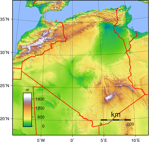
| تشريح | Topographic map of Algeria. Created with GMT from public domain GLOBE data. |
| تاريخ | |
| ذريعو | ڪم پنھنجايو |
| ليکڪ | Sadalmelik |
لائيسنسڪاري
| This work has been released into the public domain by its author, I, Sadalmelik. This applies worldwide. In some countries this may not be legally possible; if so: I, Sadalmelik grants anyone the right to use this work for any purpose, without any conditions, unless such conditions are required by law. |
فائيل جي سوانح
ڪنھن بہ تاريخ/وقت تي ٽڙڪ ڪري ڏسندا تہ ان وقت اهو فائيل ڪيئن هو.
| تاريخ/وقت | آڱوٺي ننھن | ماپَ | واپرائيندڙ | راءِ | |
|---|---|---|---|---|---|
| موجود نسخو | 18:55, 29 جُونِ 2007 | | 1,574 × 1,507 (2.96 MB) | Sadalmelik | better colours/data |
| 15:42, 22 جُونِ 2007 |  | 1,615 × 1,507 (2.32 MB) | Sadalmelik | {{Information |Description=Topographic map of Algeria. Created with GMT from public domain GLOBE data. |Source=self-made |Date=June 22, 2007 |Author= Sadalmelik }} Category:Maps of Algeria Category:Topographic maps of Africa |
ڳنڍڻا
هن فائيل سان هيٺيان صفحا ڳنڍيل آهن.
گلوبل فائيل جو استعمال
ھيٺيون وڪيز بہ ھيءُ فائيل استعمال ڪن ٿيون:
- af.wikipedia.org تي استعمال
- an.wikipedia.org تي استعمال
- ar.wikipedia.org تي استعمال
- avk.wikipedia.org تي استعمال
- bg.wikipedia.org تي استعمال
- br.wikipedia.org تي استعمال
- ca.wikipedia.org تي استعمال
- da.wikipedia.org تي استعمال
- de.wikipedia.org تي استعمال
- el.wikipedia.org تي استعمال
- en.wikipedia.org تي استعمال
- es.wikipedia.org تي استعمال
- et.wikipedia.org تي استعمال
- eu.wikipedia.org تي استعمال
- fa.wikipedia.org تي استعمال
- fo.wikipedia.org تي استعمال
- fr.wikipedia.org تي استعمال
- gl.wikipedia.org تي استعمال
- he.wikipedia.org تي استعمال
- hu.wikipedia.org تي استعمال
- hu.wiktionary.org تي استعمال
- io.wikipedia.org تي استعمال
- it.wikipedia.org تي استعمال
- la.wikipedia.org تي استعمال
- lt.wikipedia.org تي استعمال
- mdf.wikipedia.org تي استعمال
- ml.wikipedia.org تي استعمال
- ms.wikipedia.org تي استعمال
- oc.wikipedia.org تي استعمال
- ru.wikipedia.org تي استعمال
- ru.wikimedia.org تي استعمال
- sh.wikipedia.org تي استعمال
- sl.wikipedia.org تي استعمال
- sm.wikipedia.org تي استعمال
- sr.wikipedia.org تي استعمال
- th.wikipedia.org تي استعمال
ھن فائيل جو وڌيڪ گلوبل استعمال ڏسو.