
فائل:Algeria Map.jpg
هن پيش-نگاھ جي ماپ: 500*600 پڪزلس. ٻيا تحلل:200*240 پڪزلس | 400*480 پڪزلس | 640*768 پڪزلس | 1,032*1,238 پڪزلس
اصلوڪو فائيل (1,032 × 1,238 عڪسلون، فائيل سائيز: 240 KB، MIME ٽائيپ: image/jpeg)
تَتُ
| تشريح |
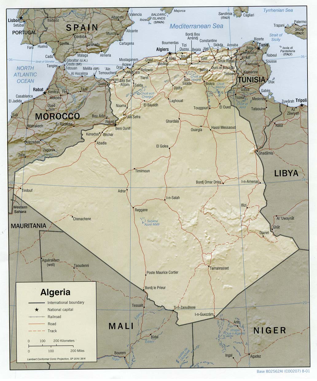
العربية: خريطة الجزائر المساعدة والمظللة، 2001. English: Shaded relief map of Algeria, 2001. |
| تاريخ | |
| ذريعو |
University of Texas Libraries, Perry-Castañeda Library Map Collection: Algeria Maps |
| ليکڪ | CIA |
لائيسنسڪاري
| This image is a work of a Central Intelligence Agency employee, taken or made as part of that person's official duties. As a Work of the United States Government, this image or media is in the public domain in the United States.
|

|
فائيل جي سوانح
ڪنھن بہ تاريخ/وقت تي ٽڙڪ ڪري ڏسندا تہ ان وقت اهو فائيل ڪيئن هو.
| تاريخ/وقت | آڱوٺي ننھن | ماپَ | واپرائيندڙ | راءِ | |
|---|---|---|---|---|---|
| موجود نسخو | 11:28, 21 فيبروري 2006 | | 1,032 × 1,238 (240 KB) | Lupo | Shaded relief map of Algeria. Source: [http://www.lib.utexas.edu/maps/africa/algeria_rel01.jpg] from the [http://www.lib.utexas.edu/maps/algeria.html Perry-Castañeda Library Map Collection]. {{PD-USGov-CIA}} Category:Maps of Algeria |
ڳنڍڻا
هن فائيل سان هيٺيان صفحا ڳنڍيل آهن.
گلوبل فائيل جو استعمال
ھيٺيون وڪيز بہ ھيءُ فائيل استعمال ڪن ٿيون:
- als.wikipedia.org تي استعمال
- ar.wikipedia.org تي استعمال
- azb.wikipedia.org تي استعمال
- de.wikipedia.org تي استعمال
- de.wiktionary.org تي استعمال
- el.wikipedia.org تي استعمال
- en.wikipedia.org تي استعمال
- eo.wikipedia.org تي استعمال
- fo.wikipedia.org تي استعمال
- frr.wikipedia.org تي استعمال
- fr.wikipedia.org تي استعمال
- hr.wiktionary.org تي استعمال
- hu.wikipedia.org تي استعمال
- hu.wiktionary.org تي استعمال
- incubator.wikimedia.org تي استعمال
- it.wikipedia.org تي استعمال
- lb.wikipedia.org تي استعمال
- ms.wikipedia.org تي استعمال
- no.wikipedia.org تي استعمال
- no.wikinews.org تي استعمال
- ru.wikipedia.org تي استعمال
- sl.wikipedia.org تي استعمال
- szy.wikipedia.org تي استعمال
- uk.wikipedia.org تي استعمال
- ur.wikipedia.org تي استعمال
- vi.wikipedia.org تي استعمال
- www.wikidata.org تي استعمال
- zh.wikipedia.org تي استعمال