
فائل:Kandahar districts.png

هن پيش-نگاھ جي ماپ: 786*600 پڪزلس. ٻيا تحلل:315*240 پڪزلس | 629*480 پڪزلس | 1,000*763 پڪزلس
اصلوڪو فائيل (1,000 × 763 عڪسلون، فائيل سائيز: 30 KB، MIME ٽائيپ: image/png)

|
This locator map image could be re-created using vector graphics as an SVG file. This has several advantages; see Commons:Media for cleanup for more information. If an SVG form of this image is available, please upload it and afterwards replace this template with
{{vector version available|new image name}}.
It is recommended to name the SVG file “Kandahar districts.svg”—then the template Vector version available (or Vva) does not need the new image name parameter. |
تَتُ
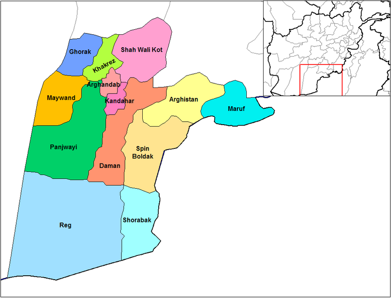
English: Map of the districts of Kandahar province of Afghanistan. Created by Rarelibra 19:26, 29 March 2007 (UTC) for public domain use, using MapInfo Professional v8.5 and various mapping resources.
لائيسنسڪاري
| I, the copyright holder of this work, release this work into the public domain. This applies worldwide. In some countries this may not be legally possible; if so: I grant anyone the right to use this work for any purpose, without any conditions, unless such conditions are required by law. |
فائيل جي سوانح
ڪنھن بہ تاريخ/وقت تي ٽڙڪ ڪري ڏسندا تہ ان وقت اهو فائيل ڪيئن هو.
| تاريخ/وقت | آڱوٺي ننھن | ماپَ | واپرائيندڙ | راءِ | |
|---|---|---|---|---|---|
| موجود نسخو | 14:47, 15 فيبروري 2024 | | 1,000 × 763 (30 KB) | User-duck | Cropped 5 % horizontally, 6 % vertically using CropTool with lossless mode. |
| 19:26, 29 مارچ 2007 |  | 1,056 × 816 (30 KB) | Rarelibra | Map of the districts of Kandahar province of Afghanistan. Created by ~~~~ for public domain use, using MapInfo Professional v8.5 and various mapping resources. |
ڳنڍڻا
هن فائيل سان هيٺيان صفحا ڳنڍيل آهن.
گلوبل فائيل جو استعمال
ھيٺيون وڪيز بہ ھيءُ فائيل استعمال ڪن ٿيون:
- ar.wikipedia.org تي استعمال
- bn.wikipedia.org تي استعمال
- ca.wikipedia.org تي استعمال
- da.wikipedia.org تي استعمال
- de.wikipedia.org تي استعمال
- en.wikipedia.org تي استعمال
- en.wikinews.org تي استعمال
- es.wikipedia.org تي استعمال
- et.wikipedia.org تي استعمال
- fr.wikipedia.org تي استعمال
- he.wikipedia.org تي استعمال
- incubator.wikimedia.org تي استعمال
- it.wikipedia.org تي استعمال
- ja.wikipedia.org تي استعمال
- lt.wikipedia.org تي استعمال
- mn.wikipedia.org تي استعمال
- ms.wikipedia.org تي استعمال
- nl.wikipedia.org تي استعمال
ھن فائيل جو وڌيڪ گلوبل استعمال ڏسو.