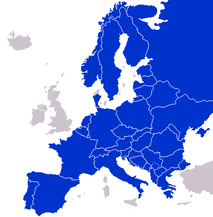
فائل:Continental-Europe-map.png
Continental-Europe-map.png (415 × 422 عڪسلون، فائيل سائيز: 12 KB، MIME ٽائيپ: image/png)
فائيل جي سوانح
ڪنھن بہ تاريخ/وقت تي ٽڙڪ ڪري ڏسندا تہ ان وقت اهو فائيل ڪيئن هو.
| تاريخ/وقت | آڱوٺي ننھن | ماپَ | واپرائيندڙ | راءِ | |
|---|---|---|---|---|---|
| موجود نسخو | 01:47, 8 سيپٽمبر 2023 |  | 415 × 422 (12 KB) | Sariyr | Exit Vendsyssel-Thy (Denmark) |
| 08:06, 18 جُولاءِ 2009 |  | 415 × 422 (14 KB) | Hoshie | redid Kosovo/Montenegro borders based on Cradel's older map; anti-alasing has been removed. | |
| 10:18, 27 سيپٽمبر 2008 |  | 415 × 422 (14 KB) | Hoshie | readded Kosovo in a different way. See talk. | |
| 03:18, 25 سيپٽمبر 2008 |  | 415 × 422 (14 KB) | Hoshie | added Montenegro and fix the tripoint between Albania, Serbia/Kosovo and Montenegro | |
| 15:40, 16 سيپٽمبر 2008 |  | 415 × 422 (10 KB) | Tocino | Reverted to version as of 00:00, 16 September 2008 | |
| 10:06, 16 سيپٽمبر 2008 |  | 415 × 422 (10 KB) | Cradel | Reverted to version as of 20:45, 15 September 2008 | |
| 00:00, 16 سيپٽمبر 2008 |  | 415 × 422 (10 KB) | Tocino | Reverted to version as of 17:25, 15 September 2008 | |
| 20:45, 15 سيپٽمبر 2008 |  | 415 × 422 (10 KB) | Cradel | Reverted to version as of 11:56, 14 September 2008 | |
| 17:25, 15 سيپٽمبر 2008 |  | 415 × 422 (10 KB) | Tocino | Reverted to version as of 14:24, 12 January 2008 | |
| 11:56, 14 سيپٽمبر 2008 |  | 415 × 422 (10 KB) | Cradel | fix |
ڳنڍڻا
ڪي بہ صفحا ناھن جيڪي ھن فائيل کي استعمال ڪندا ھجن.
گلوبل فائيل جو استعمال
ھيٺيون وڪيز بہ ھيءُ فائيل استعمال ڪن ٿيون:
- ar.wikipedia.org تي استعمال
- az.wikipedia.org تي استعمال
- bs.wikipedia.org تي استعمال
- ca.wikipedia.org تي استعمال
- ckb.wikipedia.org تي استعمال
- da.wikipedia.org تي استعمال
- de.wikipedia.org تي استعمال
- en.wikipedia.org تي استعمال
- eo.wikipedia.org تي استعمال
- es.wikipedia.org تي استعمال
- eu.wikipedia.org تي استعمال
- fa.wikipedia.org تي استعمال
- fi.wikipedia.org تي استعمال
- fo.wikipedia.org تي استعمال
- gl.wikipedia.org تي استعمال
- hy.wikipedia.org تي استعمال
- id.wikipedia.org تي استعمال
- is.wikipedia.org تي استعمال
- it.wikipedia.org تي استعمال
- ja.wikipedia.org تي استعمال
- kk.wikipedia.org تي استعمال
- ko.wikipedia.org تي استعمال
- nl.wikipedia.org تي استعمال
- nn.wikipedia.org تي استعمال
- pl.wikipedia.org تي استعمال
- pt.wikipedia.org تي استعمال
- ro.wikipedia.org تي استعمال
- ru.wikipedia.org تي استعمال
- sco.wikipedia.org تي استعمال
- sv.wikipedia.org تي استعمال
- th.wikipedia.org تي استعمال
- tr.wikipedia.org تي استعمال
- uk.wikipedia.org تي استعمال
- www.wikidata.org تي استعمال


