زيمبيا
Republic of Zambia | |||||
|---|---|---|---|---|---|
| |||||
شُعار: ' "One Zambia, One Nation" | |||||
 | |||||
| گادي جو هنڌ | Lusaka 15°25′S 28°17′E / 15.417°S 28.283°E | ||||
| سڀ کان وڏو شهر | capital | ||||
| دفتري ٻوليون | English | ||||
| تسلیم ٿيل مقامي ٻوليون | |||||
| نسلي گروھ (2010[1]) | List
| ||||
| مذهب | Christianity (official)[2] | ||||
| مقامي آبادي | Zambian | ||||
| حڪومت | Unitary presidential republic | ||||
| Hakainde Hichilema | |||||
| Mutale Nalumango | |||||
| مقننه | National Assembly | ||||
| Independence from the United Kingdom | |||||
| 27 June 1890 | |||||
| 28 November 1899 | |||||
| 29 January 1900 | |||||
| 17 August 1911 | |||||
| 1 August 1953 | |||||
| 24 October 1964 | |||||
| 5 January 2016 | |||||
| پکيڙ | |||||
• جملي |
752٬617 km2 (290٬587 sq mi)[3] (38th) | ||||
• پاڻي (%) |
1 | ||||
| آبادي | |||||
• 2023 اندازو |
20,216,029[4] (63rd) | ||||
• گھاٽائي |
17.2 /km2 (44.5 /sq mi) (191st) | ||||
| جِي ڊي پي (مساوي قوت خريد ) | 2023 لڳ ڀڳ | ||||
• ڪل |
|||||
• في سيڪڙو |
|||||
| جِي. ڊي. پي (رڳو نالي ۾ ) | 2023 لڳ ڀڳ | ||||
• ڪل |
|||||
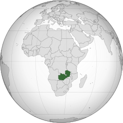
زيمبيا (Zambia) آفريڪا جي ڏاکڻي حصي ۾ موجود هڪ زمين بند ملڪ آهي. ان جي سرحد اتر ۾ جمھوري ڪانگو ۽ تنزانيا، اوڀر ۾ زمبابوي، ڏکڻ ۾ بوٽسوانا ۽ اولهه ۾ انگولا سان ملي ٿي. ملڪ جو دارالحڪومت لوساڪا ملڪ جي ڏکڻ اوڀر ۾ واقع آهي. ملڪ جي وڌیڪ تر آبادي ڏکڻ ۾ لوساڪا جي چوڌاري پکڙيل آهي. هڪ اندازي مطابق آبادي جو 10 سيڪڙو ایڊز جي پڪڙ ۾ آهي. ملڪ جي 55 سيڪڙو آبادي 2 ڊالر روزانه کان گھٽ ۾ زندگي گذاري ٿي.

Zambia,[lower-alpha 1] officially the Republic of Zambia,[lower-alpha 2] is a landlocked country at the crossroads of Central, Southern and East Africa.[8] It is typically referred to being in South-Central Africa or Southern Africa. It is bordered to the north by the Democratic Republic of the Congo, Tanzania to the north-east, Malawi to the east, Mozambique to the southeast, Zimbabwe and Botswana to the south, Namibia to the southwest, and Angola to the west. The capital city of Zambia is Lusaka, located in the south-central part of Zambia. The population is concentrated mainly around Lusaka in the south and the Copperbelt Province to the north, the core economic hubs of the country.
Originally inhabited by Khoisan peoples, the region was affected by the Bantu expansion of the thirteenth century. Following European explorers in the 18th century, the British colonised the region into the British protectorates of Barotziland–North-Western Rhodesia and North-Eastern Rhodesia towards the end of the 19th century. These were merged in 1911 to form Northern Rhodesia. For most of the colonial period, Zambia was governed by an administration appointed from London with the advice of the British South Africa Company.[9]
On 24 October 1964, Zambia became independent of the United Kingdom and prime minister Kenneth Kaunda became the inaugural president. Kaunda's socialist United National Independence Party (UNIP) maintained power from 1964 until 1991. Kaunda played a key role in regional diplomacy, cooperating closely with the United States in search of solutions to conflicts in Southern Rhodesia (Zimbabwe), Angola, and Namibia.[10] From 1972 to 1991 Zambia was a one-party state with UNIP as the sole legal political party under the motto "One Zambia, One Nation" coined by Kaunda. Kaunda was succeeded by Frederick Chiluba of the social-democratic Movement for Multi-Party Democracy in 1991, beginning a period of socio-economic development and government decentralisation. Zambia has since become a multi-party state and has experienced several peaceful transitions of power.
Zambia contains abundant natural resources, including minerals, wildlife, forestry, freshwater, and arable land.[11] In 2010, the World Bank named Zambia among the top 10 reformers in the World Bank's Ease of doing business index.[12] The Common Market for Eastern and Southern Africa (COMESA) is headquartered in Lusaka.
حوالا[سنواريو]
- ↑ Census of Population and Housing National Analytical Report 2010 Central Statistical Office, Zambia
- ↑ "Amended Constitution of Zambia". Government of Zambia. حاصل ڪيل 15 October 2016.
- ↑ United Nations Statistics Division. "Population by sex, rate of population increase, surface area and density" (PDF). حاصل ڪيل 9 November 2007.
- ↑ سانچو:Cite CIA World Factbook
- ↑ 5.0 5.1 5.2 5.3 "World Economic Outlook Database, October 2023 Edition. (Zambia)". International Monetary Fund. حاصل ڪيل 15 October 2023.
- ↑ "Gini Index". World Bank. حاصل ڪيل 2 September 2019.
- ↑ Human Development Report 2020: The Next Frontier: Human Development and the Anthropocene. United Nations Development Programme. 15 December 2020. pp. 343–346. ISBN 978-92-1-126442-5. http://hdr.undp.org/sites/default/files/hdr2020.pdf. Retrieved 16 December 2020.
- ↑ Henderson, Ian (1970). "The Origins of Nationalism in East and Central Africa: The Zambian Case". The Journal of African History 11 (4): 591–603. doi:. ISSN 0021-8537.
- ↑ "History | Zambian High Commission". www.zambiapretoria.net. حاصل ڪيل 26 May 2020.
- ↑ Andy DeRoche, Kenneth Kaunda, the United States, and Southern Africa (London: Bloomsbury, 2016).
- ↑ Eckman, Karlyn, Gender Mainstreaming in Forestry in Africa: Zambia, Food and Agriculture Organization
- ↑ Ngoma, Jumbe (18 December 2010). "World Bank President Praises Reforms In Zambia, Underscores Need For Continued Improvements In Policy And Governance". World Bank.
حوالي جي چڪ: "lower-alpha" نالي جي حوالن جي لاءِ ٽيگ <ref> آهن، پر لاڳاپيل ٽيگ <references group="lower-alpha"/> نہ مليو


