
فائل:WestAfrica1625.png
اڃان سنھو تحلل ميسر ناھي.
WestAfrica1625.png (498 × 306 عڪسلون، فائيل سائيز: 31 KB، MIME ٽائيپ: image/png)

|
This historical map image could be re-created using vector graphics as an SVG file. This has several advantages; see Commons:Media for cleanup for more information. If an SVG form of this image is available, please upload it and afterwards replace this template with
{{vector version available|new image name}}.
It is recommended to name the SVG file “WestAfrica1625.svg”—then the template Vector version available (or Vva) does not need the new image name parameter. |
تَتُ
| تشريح |
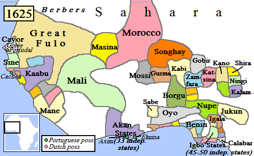
English: Map of West Africa, AD 1625.
(Partially based on Atlas of World History (2007) - Early modern Africa, map.) |
| تاريخ | |
| ذريعو | ڪم پنھنجايو |
| ليکڪ | Gabagool |
لائيسنسڪاري
I, the copyright holder of this work, hereby publish it under the following license:
This file is licensed under the Creative Commons Attribution 3.0 Unported license.
- توھان آزاد آھيو:
- ونڊڻ لاءِ – اھو ڪم نقل ڪرڻ، ورڇڻ، ۽ پارمڪارڻ
- جڳلبندي ڪرڻ – ڪم اختيار ڪرڻ لاءِ
- ھيٺين شرطن تي:
- انتساب – توهان لازماً مناسب انتساب ڏيو، اجازتنامي ڏانھن ڳنڍڻو مھيا ڪريو، ۽ جيڪڏھن ڪي تبديليون ڪيون ويون ھجن تہ انھن جي نشاندھي ڪريو. توهان اهو ڪري سگهو ٿا ڪنھن بہ معقول طريقي سان، پر ڪنھن بہ اھڙي طريقي سان نہ جيڪو ڏسي تہ اجازتنامو ڏيندڙ توهان جي يا توهان جي استعمال جي توثيق ڪري ٿو.
فائيل جي سوانح
ڪنھن بہ تاريخ/وقت تي ٽڙڪ ڪري ڏسندا تہ ان وقت اهو فائيل ڪيئن هو.
| تاريخ/وقت | آڱوٺي ننھن | ماپَ | واپرائيندڙ | راءِ | |
|---|---|---|---|---|---|
| موجود نسخو | 17:42, 5 مَئي 2010 | | 498 × 306 (31 KB) | Omar-Toons | Reverted to version as of 00:15, 16 June 2009 |
| 18:05, 20 اپريل 2010 |  | 497 × 306 (31 KB) | Bokpasa | Saadi dynasty and Tuaregs | |
| 00:15, 16 جُونِ 2009 |  | 498 × 306 (31 KB) | Gabagool | rm lines | |
| 19:57, 19 اپريل 2009 |  | 498 × 306 (32 KB) | Gabagool | {{Information |Description={{en|1=Map of West Africa, AD 1625. (Partially based on ''Atlas of World History'' (2007) - Early modern Africa, map.)}} |Source=Own work by uploader |Author=Gabagool |Date=2009-04-19 |Permission= |other_versi |
ڳنڍڻا
هن فائيل سان هيٺيان صفحا ڳنڍيل آهن.
گلوبل فائيل جو استعمال
ھيٺيون وڪيز بہ ھيءُ فائيل استعمال ڪن ٿيون:
- af.wikipedia.org تي استعمال
- als.wikipedia.org تي استعمال
- ar.wikipedia.org تي استعمال
- azb.wikipedia.org تي استعمال
- bn.wikipedia.org تي استعمال
- ca.wikipedia.org تي استعمال
- da.wikipedia.org تي استعمال
- de.wikipedia.org تي استعمال
- en.wikipedia.org تي استعمال
- Mali Empire
- Songhai Empire
- Songhai people
- Sahelian kingdoms
- Oyo Empire
- History of West Africa
- Islamization of the Sudan region
- Kaabu
- Empire of Great Fulo
- Dendi (province)
- Legends of Africa
- Timeline of Nigerian history
- List of kingdoms in Africa throughout history
- Military history of the Mali Empire
- Nigerian traditional rulers
- User:OnBeyondZebrax/sandbox/African history
- User:Tisquesusa/sandbox9
- The Songhai
- Medieval and early modern Africa
- en.wikibooks.org تي استعمال
ھن فائيل جو وڌيڪ گلوبل استعمال ڏسو.