
فائل:The Border on Killeen School Road - geograph.org.uk - 446719.jpg
اڃان سنھو تحلل ميسر ناھي.
The_Border_on_Killeen_School_Road_-_geograph.org.uk_-_446719.jpg (640 × 480 عڪسلون، فائيل سائيز: 71 KB، MIME ٽائيپ: image/jpeg)
تَتُ
| تشريح |
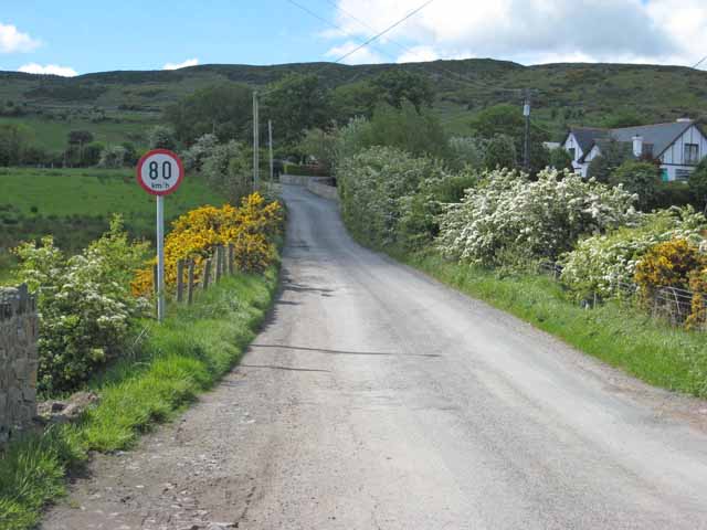
English: The Irish Border between Northern Ireland and Ireland on Killeen School Road in Killeen, County Armagh, in Northern Ireland. The only indication that one is crossing into the Republic of Ireland is the speed limit sign expressed in kilometres per hour. There are no indications when one is travelling in the opposite direction. The Cooley Mountains are in the background. |
| تاريخ | |
| ذريعو | From geograph.org.uk |
| ليکڪ | Oliver Dixon |
| انتساب (required by the license) | Oliver Dixon / The Border on Killeen School Road / |
| Camera location | | View this and other nearby images on: OpenStreetMap |
|---|
_heading:202.00&language=sd)
| Object location | | View this and other nearby images on: OpenStreetMap |
|---|
_heading:202.00&language=sd)
لائيسنسڪاري

|
This image was taken from the Geograph project collection. See this photograph's page on the Geograph website for the photographer's contact details. The copyright on this image is owned by Oliver Dixon and is licensed for reuse under the Creative Commons Attribution-ShareAlike 2.0 license.
|
This file is licensed under the Creative Commons Attribution-Share Alike 2.0 Generic license.
انتساب: Oliver Dixon
- توھان آزاد آھيو:
- ونڊڻ لاءِ – اھو ڪم نقل ڪرڻ، ورڇڻ، ۽ پارمڪارڻ
- جڳلبندي ڪرڻ – ڪم اختيار ڪرڻ لاءِ
- ھيٺين شرطن تي:
- انتساب – توهان لازماً مناسب انتساب ڏيو، اجازتنامي ڏانھن ڳنڍڻو مھيا ڪريو، ۽ جيڪڏھن ڪي تبديليون ڪيون ويون ھجن تہ انھن جي نشاندھي ڪريو. توهان اهو ڪري سگهو ٿا ڪنھن بہ معقول طريقي سان، پر ڪنھن بہ اھڙي طريقي سان نہ جيڪو ڏسي تہ اجازتنامو ڏيندڙ توهان جي يا توهان جي استعمال جي توثيق ڪري ٿو.
- ھڪجھڙي ڀاڱيداري – جيڪڏھن توھان ٻيھر ملاوٽ، بدلاءُ، يا مواد تي اڏاوت ڪريو ٿا، توھان کي لازماً پنھنجون ڀاڱيداريون ساڳي يا موافق اجازتنامي جھڙو اصل جو ھيو، ھيٺ ٻيھر-ورھائڻ گهرجن.
فائيل جي سوانح
ڪنھن بہ تاريخ/وقت تي ٽڙڪ ڪري ڏسندا تہ ان وقت اهو فائيل ڪيئن هو.
| تاريخ/وقت | آڱوٺي ننھن | ماپَ | واپرائيندڙ | راءِ | |
|---|---|---|---|---|---|
| موجود نسخو | 12:45, 4 فيبروري 2011 | | 640 × 480 (71 KB) | GeographBot | == {{int:filedesc}} == {{Information |description={{en|1=The Border on Killeen School Road The only indication that one is crossing into the Irish Republic is the speed limit sign expressed in Kilometres per hour. Cooley Mountains in the background.}} |da |
ڳنڍڻا
هن فائيل سان هيٺيان صفحا ڳنڍيل آهن.
گلوبل فائيل جو استعمال
ھيٺيون وڪيز بہ ھيءُ فائيل استعمال ڪن ٿيون:
- ar.wikipedia.org تي استعمال
- ca.wikipedia.org تي استعمال
- de.wikipedia.org تي استعمال
- en.wikipedia.org تي استعمال
- en.wikivoyage.org تي استعمال
- fr.wikipedia.org تي استعمال
- id.wikipedia.org تي استعمال
- it.wikipedia.org تي استعمال
- ja.wikipedia.org تي استعمال
- ko.wikipedia.org تي استعمال
- ms.wikipedia.org تي استعمال
- no.wikipedia.org تي استعمال
- pnb.wikipedia.org تي استعمال
- pt.wikipedia.org تي استعمال
- ru.wikipedia.org تي استعمال
- uk.wikipedia.org تي استعمال
- ur.wikipedia.org تي استعمال
- www.wikidata.org تي استعمال