
فائل:Road network CPEC.jpg
هن پيش-نگاھ جي ماپ: 799*600 پڪزلس. ٻيا تحلل:320*240 پڪزلس | 640*480 پڪزلس | 962*722 پڪزلس
اصلوڪو فائيل (962 × 722 عڪسلون، فائيل سائيز: 137 KB، MIME ٽائيپ: image/jpeg)
تَتُ
| تشريح |
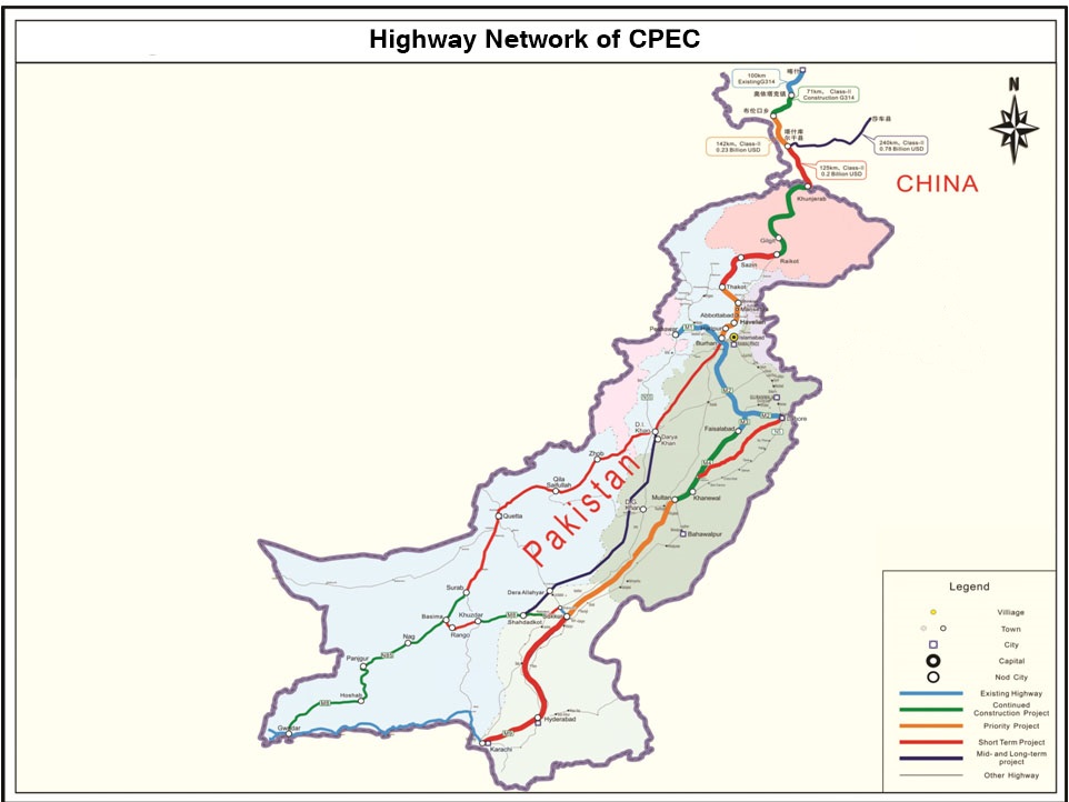
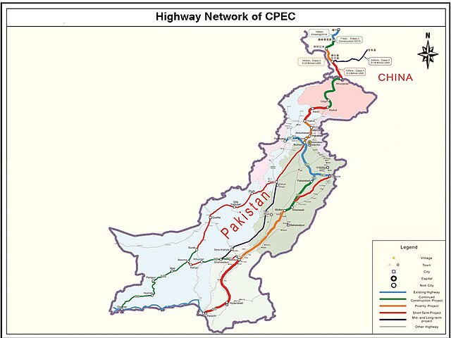
English: It describes Eastern Western and Central alignment of CPEC |
| تاريخ | |
| ذريعو | http://www.pc.gov.pk/wp-content/uploads/2016/01/Highway-Network-of-cpac-new.jpg |
| ليکڪ | Government of Pakistan |
This file is in the public domain because Planning commision of Pakistan
|
فائيل جي سوانح
ڪنھن بہ تاريخ/وقت تي ٽڙڪ ڪري ڏسندا تہ ان وقت اهو فائيل ڪيئن هو.
| تاريخ/وقت | آڱوٺي ننھن | ماپَ | واپرائيندڙ | راءِ | |
|---|---|---|---|---|---|
| موجود نسخو | 00:19, 28 سيپٽمبر 2023 | | 962 × 722 (137 KB) | Eggrollll | Reverted to version as of 17:10, 4 December 2020 (UTC) |
| 17:11, 4 ڊسمبر 2020 |  | 962 × 722 (125 KB) | Pathfinder454 | Map published by user Badri2017 is forged / edited without copyrights obtained from Government of Pakistan. Original file published by user Baltistani478 is the actual map depicting road networks of CPEC as published at official website http://cpec.gov.pk/map-single/1 Therefore File Reverted to version as of 16:49, 23 May 2016 (UTC) | |
| 17:10, 4 ڊسمبر 2020 |  | 962 × 722 (137 KB) | Pathfinder454 | Reverted to version as of 10:15, 19 July 2017 (UTC) Map published by user Badri2017 is forged / edited without copyrights obtained from Government of Pakistan. Original file published by user Baltistani478 is the actual map depicting road networks of CPEC as published at official website http://cpec.gov.pk/map-single/1 Therefore File Reverted to version as of 16:49, 23 May 2016 (UTC | |
| 17:01, 4 ڊسمبر 2020 |  | 962 × 722 (125 KB) | Pathfinder454 | Map published by user Badri2017 is forged / edited without copyrights obtained from Government of Pakistan. Original file published by user Baltistani478 is the actual map depicting road networks of CPEC as published at official website http://cpec.gov.pk/map-single/1 Therefore File Reverted to version as of 16:49, 23 May 2016 (UTC) | |
| 10:15, 19 جُولاءِ 2017 |  | 962 × 722 (137 KB) | Badri2017 | Neutral Map, Indian administered Kashmir is neither part of CPEC nor Pak territory | |
| 16:49, 23 مَئي 2016 |  | 962 × 722 (125 KB) | Baltistani478 | {{subst:Upload marker added by en.wp UW}} {{Information |Description = {{en|It describes Eastern Western and Central alignment of CPEC}} |Source = http://www.pc.gov.pk/wp-content/uploads/2016/01/Highway-Network-of-cpac-new.jpg |Date = January 2016 |Aut... |
ڳنڍڻا
هن فائيل سان هيٺيان صفحا ڳنڍيل آهن.
گلوبل فائيل جو استعمال
ھيٺيون وڪيز بہ ھيءُ فائيل استعمال ڪن ٿيون:
- ar.wikipedia.org تي استعمال
- bn.wikipedia.org تي استعمال
- ca.wikipedia.org تي استعمال
- en.wikipedia.org تي استعمال
- eo.wikinews.org تي استعمال
- hi.wikipedia.org تي استعمال
- mr.wikipedia.org تي استعمال
- pa.wikipedia.org تي استعمال
- pnb.wikipedia.org تي استعمال
- sat.wikipedia.org تي استعمال
- ta.wikipedia.org تي استعمال
- zh.wikipedia.org تي استعمال