
فائل:Population density of Ireland map2002.svg

Size of this PNG preview of this SVG file: 480*600 پڪزلس. ٻيا تحلل:192*240 پڪزلس | 384*480 پڪزلس | 614*768 پڪزلس | 819*1,024 پڪزلس | 1,638*2,048 پڪزلس
اصلوڪو فائيل (ايسويجي فائيل، اٽڪل 800 × 1,000 عڪسلون، فائيل سائيز: 621 KB)
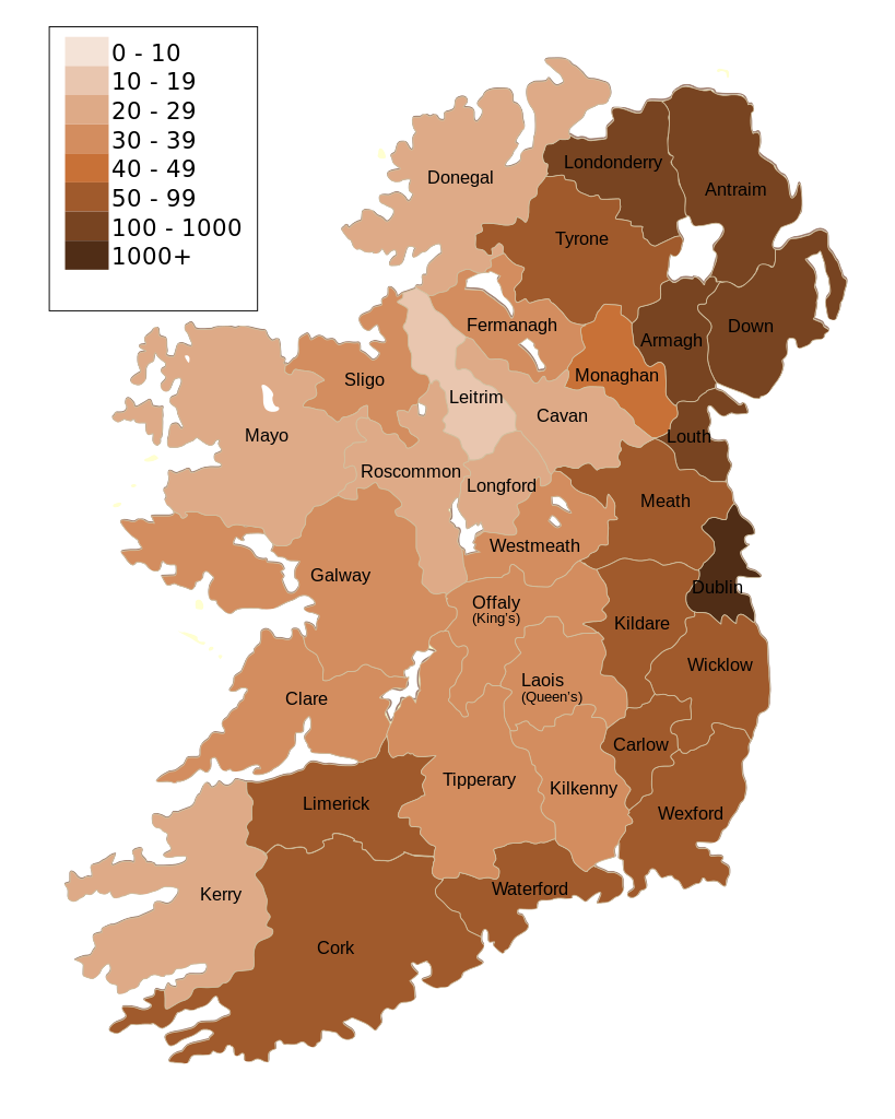
| تشريح | Map of Ireland's population density (people per km2). Based upon Republic of Ireland - 2002 Census results. |
| تاريخ | (UTC) |
| ذريعو | |
| ليکڪ |
|
| Other versions | Derivative works of this file: Population density of Ireland map2002 RU.svg |
| This is a retouched picture, which means that it has been digitally altered from its original version. Modifications: Map of Ireland's population density (people per km2). Based upon Republic of Ireland - 2002 Census results.. The original can be viewed here: Ireland complete.svg:
|
I, the copyright holder of this work, hereby publish it under the following license:
| I, the copyright holder of this work, release this work into the public domain. This applies worldwide. In some countries this may not be legally possible; if so: I grant anyone the right to use this work for any purpose, without any conditions, unless such conditions are required by law. |
Original upload log
This image is a derivative work of the following images:
- File:Ireland_complete.svg licensed with PD-self
- 2007-06-23T17:06:44Z Future Perfect at Sunrise 800x1000 (594536 Bytes) {{Information |Description= |Source=self-made |Date= |Author= [[User:Future Perfect at Sunrise|Future Perfect at Sunrise]] }}
- 2007-06-23T16:45:52Z Future Perfect at Sunrise 800x1000 (590003 Bytes) {{Information |Description= |Source=self-made |Date= |Author= [[User:Future Perfect at Sunrise|Future Perfect at Sunrise]] }}
- 2007-06-23T16:35:48Z Future Perfect at Sunrise 2000x2500 (606764 Bytes) {{Information |Description=SVG map of Ireland. |Source=self-made |Date=23 June 2007 |Author= [[User:Future Perfect at Sunrise|Future Perfect at Sunrise]] }} Note: the SVG code contains separate levels showing boundaries and
Uploaded with derivativeFX
فائيل جي سوانح
ڪنھن بہ تاريخ/وقت تي ٽڙڪ ڪري ڏسندا تہ ان وقت اهو فائيل ڪيئن هو.
| تاريخ/وقت | آڱوٺي ننھن | ماپَ | واپرائيندڙ | راءِ | |
|---|---|---|---|---|---|
| موجود نسخو | 14:30, 17 آڪٽوبر 2009 | | 800 × 1,000 (621 KB) | The Illusional Ministry | Dublin now in black text |
| 14:27, 17 آڪٽوبر 2009 |  | 800 × 1,000 (621 KB) | The Illusional Ministry | {{Information |Description=Map of Ireland's population density (people per km2). Based upon Republic of Ireland - 2002 Census results. |Source=*File:Ireland_complete.svg |Date=2009-10-17 14:25 (UTC) |Author=*File:Ireland_complete.svg: '''Futur |
ڳنڍڻا
هن فائيل سان هيٺيان صفحا ڳنڍيل آهن.
گلوبل فائيل جو استعمال
ھيٺيون وڪيز بہ ھيءُ فائيل استعمال ڪن ٿيون:
- de.wikipedia.org تي استعمال
- gv.wikipedia.org تي استعمال
- he.wikipedia.org تي استعمال
- hu.wikipedia.org تي استعمال
- kn.wikipedia.org تي استعمال
- te.wikipedia.org تي استعمال