
فائل:Italy and Possessions September 1939.png

هن پيش-نگاھ جي ماپ: 800*351 پڪزلس. ٻيا تحلل:320*140 پڪزلس | 640*281 پڪزلس | 1,425*625 پڪزلس
اصلوڪو فائيل (1,425 × 625 عڪسلون، فائيل سائيز: 29 KB، MIME ٽائيپ: image/png)
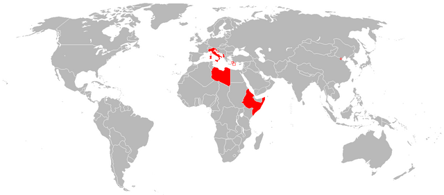
تَتُ
| تشريح |
English: Italian Colonial Empire |
| تاريخ | |
| ذريعو |
|
| ليکڪ | The Red Hat of Pat Ferrick t |
لائيسنسڪاري
| This work has been released into the public domain by its author, The Red Hat of Pat Ferrick at انگريزي وڪيپيڊيا. This applies worldwide. In some countries this may not be legally possible; if so: The Red Hat of Pat Ferrick grants anyone the right to use this work for any purpose, without any conditions, unless such conditions are required by law. |
Original upload log
The original description page was here. All following user names refer to en.wikipedia.
- 2013-12-29 13:54 Thomas.W 1425×625× (29507 bytes) Reverted to version as of 13:02, 7 September 2010 because of deliberate manipulation of the image, adding territory that wasn't formally Italian.
- 2013-12-29 13:46 Nick.mon 1425×625× (39462 bytes) Better colors
- 2010-09-07 13:02 -kayac71- 1425×625× (29507 bytes) correction of an error in the Dodecanese border
- 2010-09-07 12:57 -kayac71- 1425×625× (29506 bytes) error in the map: the Aouzou strip was not comprised
- 2008-08-10 23:22 R-41 1425×625× (31103 bytes) Larger map showing Italy and its possessions in September 1939. Now the Italian miniscule holding in Tianjin is represented, along with red circles and outlining to show tiny areas controlled by Italy.
- 2008-06-29 15:42 The Red Hat of Pat Ferrick 344×241× (6030 bytes) {{Information |Description=Based on http://en.wikipedia.org/wiki/Image:Italian_empire_1940.PNG |Source=I created this work entirely by myself. |Date=29 June 2008 |Author=~~~ |other_versions= }} (version lost by MediaWiki)
فائيل جي سوانح
ڪنھن بہ تاريخ/وقت تي ٽڙڪ ڪري ڏسندا تہ ان وقت اهو فائيل ڪيئن هو.
| تاريخ/وقت | آڱوٺي ننھن | ماپَ | واپرائيندڙ | راءِ | |
|---|---|---|---|---|---|
| موجود نسخو | 16:29, 25 مَئي 2014 | | 1,425 × 625 (29 KB) | OgreBot | (BOT): Reverting to most recent version before archival |
| 16:29, 25 مَئي 2014 |  | 1,425 × 625 (39 KB) | OgreBot | (BOT): Uploading old version of file from en.wikipedia; originally uploaded on 2013-12-29 13:46:48 by Nick.mon | |
| 16:29, 25 مَئي 2014 |  | 1,425 × 625 (29 KB) | OgreBot | (BOT): Uploading old version of file from en.wikipedia; originally uploaded on 2010-09-07 12:57:38 by -kayac71- | |
| 16:29, 25 مَئي 2014 |  | 1,425 × 625 (30 KB) | OgreBot | (BOT): Uploading old version of file from en.wikipedia; originally uploaded on 2008-08-10 23:22:48 by R-41 | |
| 00:27, 27 فيبروري 2014 |  | 1,425 × 625 (29 KB) | Grachifan | User created page with UploadWizard |
ڳنڍڻا
هن فائيل سان هيٺيان صفحا ڳنڍيل آهن.
گلوبل فائيل جو استعمال
ھيٺيون وڪيز بہ ھيءُ فائيل استعمال ڪن ٿيون:
- ar.wikipedia.org تي استعمال
- de.wikipedia.org تي استعمال
- es.wikipedia.org تي استعمال
- fa.wikipedia.org تي استعمال
- fr.wikipedia.org تي استعمال
- gl.wikipedia.org تي استعمال
- hu.wikipedia.org تي استعمال
- id.wikipedia.org تي استعمال
- it.wikipedia.org تي استعمال
- lt.wikipedia.org تي استعمال
- sl.wikipedia.org تي استعمال
- th.wikipedia.org تي استعمال
- ur.wikipedia.org تي استعمال
- vec.wikipedia.org تي استعمال