
فائل:Ecuador Topography.png

هن پيش-نگاھ جي ماپ: 539*600 پڪزلس. ٻيا تحلل:216*240 پڪزلس | 431*480 پڪزلس | 903*1,005 پڪزلس
اصلوڪو فائيل (903 × 1,005 عڪسلون، فائيل سائيز: 864 KB، MIME ٽائيپ: image/png)
تَتُ
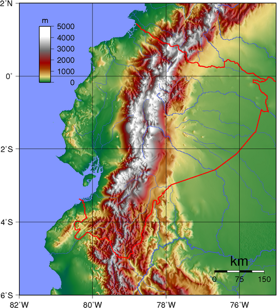
| تشريح | Topographic map of Ecuador. Created with GMT from public GLOBE data. |
| تاريخ | |
| ذريعو | ڪم پنھنجايو |
| ليکڪ | Sadalmelik |
لائيسنسڪاري
| This work has been released into the public domain by its author, I, Sadalmelik. This applies worldwide. In some countries this may not be legally possible; if so: I, Sadalmelik grants anyone the right to use this work for any purpose, without any conditions, unless such conditions are required by law. |
فائيل جي سوانح
ڪنھن بہ تاريخ/وقت تي ٽڙڪ ڪري ڏسندا تہ ان وقت اهو فائيل ڪيئن هو.
| تاريخ/وقت | آڱوٺي ننھن | ماپَ | واپرائيندڙ | راءِ | |
|---|---|---|---|---|---|
| موجود نسخو | 19:32, 12 جُونِ 2007 | | 903 × 1,005 (864 KB) | Sadalmelik | {{Information |Description=Topographic map of Ecuador. Created with GMT from public GLOBE data. |Source=self-made |Date=June 12, 2007 |Author= Sadalmelik }} Category:Maps of Ecuador Category:Topographic maps of the Americas |
ڳنڍڻا
هن فائيل سان هيٺيان صفحا ڳنڍيل آهن.
گلوبل فائيل جو استعمال
ھيٺيون وڪيز بہ ھيءُ فائيل استعمال ڪن ٿيون:
- af.wikipedia.org تي استعمال
- ar.wikipedia.org تي استعمال
- azb.wikipedia.org تي استعمال
- bg.wikipedia.org تي استعمال
- blk.wikipedia.org تي استعمال
- bn.wikipedia.org تي استعمال
- da.wikipedia.org تي استعمال
- de.wikipedia.org تي استعمال
- en.wikipedia.org تي استعمال
- en.wikiquote.org تي استعمال
- eu.wikipedia.org تي استعمال
- fa.wikipedia.org تي استعمال
- fr.wikipedia.org تي استعمال
- hu.wikipedia.org تي استعمال
- it.wikipedia.org تي استعمال
- ja.wikipedia.org تي استعمال
- ka.wikipedia.org تي استعمال
- nds-nl.wikipedia.org تي استعمال
- pt.wikipedia.org تي استعمال
- qu.wikipedia.org تي استعمال
- ru.wikipedia.org تي استعمال
- te.wikipedia.org تي استعمال
- tr.wikipedia.org تي استعمال
- tt.wikipedia.org تي استعمال
- uk.wikipedia.org تي استعمال
- ur.wikipedia.org تي استعمال
- vep.wikipedia.org تي استعمال
- zh.wikipedia.org تي استعمال