
فائل:Canada provinces evolution 2.gif

هن پيش-نگاھ جي ماپ: 694*600 پڪزلس. ٻيا تحلل:278*240 پڪزلس | 556*480 پڪزلس | 1,000*864 پڪزلس
اصلوڪو فائيل (1,000 × 864 عڪسلون، فائيل سائيز: 243 KB، MIME ٽائيپ: image/gif، looped، 20 فريمَ، 1 min 13 s)

|
This image could be re-created using vector graphics as an SVG file. This has several advantages; see Commons:Media for cleanup for more information. If an SVG form of this image is available, please upload it and afterwards replace this template with
{{vector version available|new image name}}.
It is recommended to name the SVG file "Canada provinces evolution 2.svg" - then the template Vector version available (or Vva) does not need the new image name parameter. |
|
تَتُ
| تشريح |
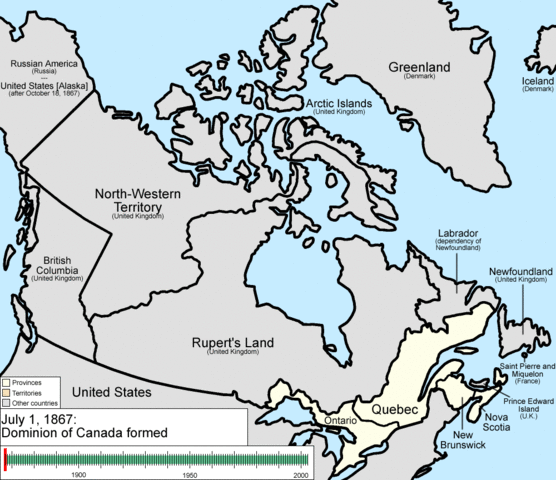
English: Animation of the changes to the borders of Canada.
The captions read as follows:
|
| تاريخ | |
| ذريعو | ڪم پنھنجايو |
| ليکڪ | Golbez |
لائيسنسڪاري
I, the copyright holder of this work, hereby publish it under the following licenses:
ھي فائيل ڪريئيٽو ڪامنز انتساب-ھڪجھڙي ڀاڱيداري 3.0 انپورٽڊ اجازتنامي ھيٺ اجازتنامو ڏنل آھي.
- توھان آزاد آھيو:
- ونڊڻ لاءِ – اھو ڪم نقل ڪرڻ، ورڇڻ، ۽ پارمڪارڻ
- جڳلبندي ڪرڻ – ڪم اختيار ڪرڻ لاءِ
- ھيٺين شرطن تي:
- انتساب – توهان لازماً مناسب انتساب ڏيو، اجازتنامي ڏانھن ڳنڍڻو مھيا ڪريو، ۽ جيڪڏھن ڪي تبديليون ڪيون ويون ھجن تہ انھن جي نشاندھي ڪريو. توهان اهو ڪري سگهو ٿا ڪنھن بہ معقول طريقي سان، پر ڪنھن بہ اھڙي طريقي سان نہ جيڪو ڏسي تہ اجازتنامو ڏيندڙ توهان جي يا توهان جي استعمال جي توثيق ڪري ٿو.
- ھڪجھڙي ڀاڱيداري – جيڪڏھن توھان ٻيھر ملاوٽ، بدلاءُ، يا مواد تي اڏاوت ڪريو ٿا، توھان کي لازماً پنھنجون ڀاڱيداريون ساڳي يا موافق اجازتنامي جھڙو اصل جو ھيو، ھيٺ ٻيھر-ورھائڻ گهرجن.

|
ھن دستاويز کي جي.اين.يو مفت دستاويزسازي اجازتنامي ، مفت سافٽويئر فائونڊيشن پاران ڇاپيل ورزن 1.2 يا ٻي ڪنھن بعد واري ورزن؛ جنھن ۾ نہ انويريئينٽ ڀاڱا، ۽ نہ فونٽ-ڪور متنَ، ۽ نہ بيڪ-ڪور متنَ شامل آھن، جي شرطن ھيٺ نقل ڪرڻ، ورھائن ۽/يا بدلائڻ جي اجازت ڏني وئي آھي. اجازتنامي جو نقل [[c:Commons:GNU Free Documentation License, version 1.2 | جي.اين.يو مفت دستاويزسازي اجازتنامو]] نالي ڀاڱي ۾ ڏنل آھي. |
توھان پنھنجي پسند جو اجازتنامو چونڊي سگهو ٿا.
فائيل جي سوانح
ڪنھن بہ تاريخ/وقت تي ٽڙڪ ڪري ڏسندا تہ ان وقت اهو فائيل ڪيئن هو.
| تاريخ/وقت | آڱوٺي ننھن | ماپَ | واپرائيندڙ | راءِ | |
|---|---|---|---|---|---|
| موجود نسخو | 22:37, 14 جُولاءِ 2009 | | 1,000 × 864 (243 KB) | Golbez | {{Information |Description=Animation of the changes to the borders of Canada. |Source=self-made |Date=July 15, 2009 |Author= Golbez |Permission= |other_versions= }} Category:Maps of the history of Canada Category:Animated GIF [[Ca |
ڳنڍڻا
هن فائيل سان هيٺيان صفحا ڳنڍيل آهن.
گلوبل فائيل جو استعمال
ھيٺيون وڪيز بہ ھيءُ فائيل استعمال ڪن ٿيون:
- ar.wikipedia.org تي استعمال
- be-tarask.wikipedia.org تي استعمال
- bg.wikipedia.org تي استعمال
- ca.wikipedia.org تي استعمال
- ckb.wikipedia.org تي استعمال
- cs.wikipedia.org تي استعمال
- en.wikipedia.org تي استعمال
- John A. Macdonald
- Manitoba
- Northwest Territories
- Ontario
- History of Canada
- Provinces and territories of Canada
- Talk:Labrador
- List of proposed provinces and territories of Canada
- Quebec Boundaries Extension Act, 1912
- History of Alberta
- Quebec Boundary Extension Act, 1898
- History of Western civilization
- Wikipedia:Featured pictures thumbs/06
- Canada
- Talk:Territorial evolution of Canada
- List of Canada-related topics by provinces and territories
- Demographics of the Northwest Territories
- Speaker of the Legislative Assembly of the Northwest Territories
- Portal:Canada/Selected picture
- Wikipedia:Featured pictures/Diagrams, drawings, and maps/Maps
- Wikipedia:Featured picture candidates/delist/2009
- Wikipedia:Featured picture candidates/delist/Canada provinces evolution.gif
- Talk:History of Canada/Archive 1
- Wikipedia:Featured picture candidates/November-2009
- Wikipedia:Featured picture candidates/Non-Native American Nations Control over N America 1750-2008.gif
- User:North8000
- User:Ezekiel11324/bordercity
- Former colonies and territories in Canada
- User:Soulscanner/Sandbox/CanHist
- Wikipedia:Reference desk/Archives/Miscellaneous/2011 August 15
- User talk:Golbez/Archive 6
- Template:POTD/2015-07-01
- Wikipedia:Picture of the day/July 2015
- Wikipedia:Main Page history/2015 July 1
- User:PMK2000/sandbox/Canada
- Timeline of Alberta history
- en.wikibooks.org تي استعمال
- es.wikipedia.org تي استعمال
ھن فائيل جو وڌيڪ گلوبل استعمال ڏسو.