فائل:Breakup of Yugoslavia.gif
Page contents not supported in other languages.
کليل ڄاڻ چيڪلي، وڪيپيڊيا مان

اصلوڪو فائيل(1,545 × 1,242 عڪسلون، فائيل سائيز: 187 KB، MIME ٽائيپ: image/gif، looped، 14 فريمَ، 44 s)

ھي فائيل وڪيميڊيا العام مان آھي ۽ ٻين رٿائن پاران پڻ استعمال ٿي سگهي ٿو. تشريح انجي [فائيل جي تشريحي صفحي] ھيٺان ڏنل آھي.

This image could be re-created using vector graphics as an SVG file. This has several advantages; see Commons:Media for cleanup for more information. If an SVG form of this image is available, please upload it and afterwards replace this template with {{vector version available|new image name}}. It is recommended to name the SVG file "Breakup of Yugoslavia.svg" - then the template Vector version available (or Vva) does not need the new image name parameter.

تَتُ

Key:

Yugoslavia (1943–1992) SFR Yugoslavia
Croatia (1991–present) Croatia
Herzeg-Bosnia (1992–1994)
UNTAES (1996–1998)
Federal Republic of Yugoslavia / Serbia and Montenegro (1992–2006) Serbia and Montenegro
Republika Srpska (1992–present) Republika Srpska
Serbian Krajina (1991–1995/96)
Republic of Bosnia and Herzegovina (1992–1995)
Bosnia and Herzegovina (1998–present) Bosnia and Herzegovina
Western Bosnia (1993–1995)
Serbia (2006–present) Serbia
Kosovo (under UNMIK control 1999–present; declaration of independence 2008) Kosovo
Montenegro (2006–present) Montenegro
Macedonia (1991–present) Macedonia
Slovenia (1991–present) Slovenia


تشريح

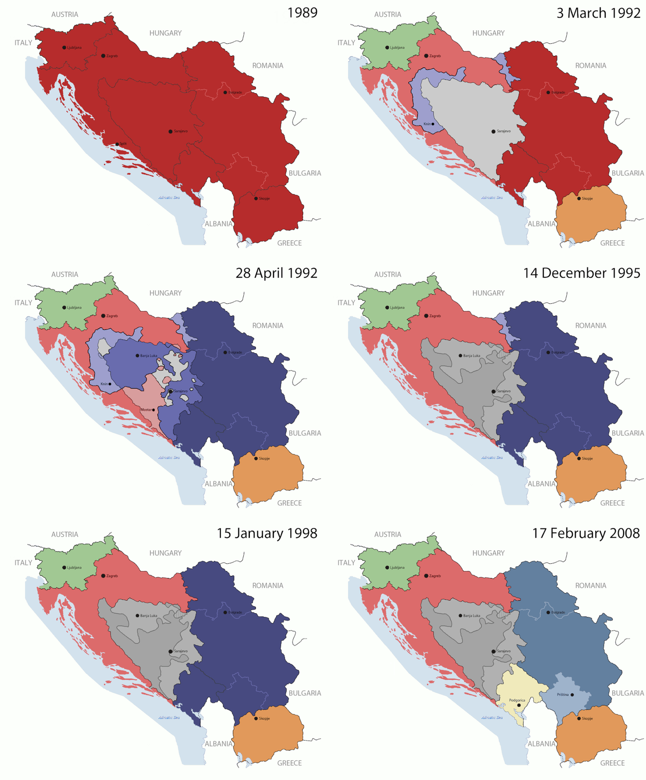
This is an animated GIF that shows the stages of the breakup of the SFR Yugoslavia in the 90's and 2000's. The map based off Morwen's map of the divisions of the SFRY, Which is licensed by the GFDL. The source for the dates of independence is the CIA World Factbook. These maps do not now show the Inter-Entity Boundary Line (IEBL) and/or the entities that are separated by it. The IEBL has been drawn based on this CIA map; the Brčko District has been drawn based on Image:BH municipality location.gif, by user:Ante Perkovic. I might add them in the future.

Since the original map was GFDL, this image is as well.

A map depicting Kosovo's final status is ready once it takes effect.


Changelog for versions 2/3:

Here are some changes in this new build of the map:

  • The Kosovo boundary has been given a shade of red instead of the previous UN blue since they are a province of Serbia under UNIMIK control.
  • Montenegro's color has been changed to a golden shade close to what's on the flag.
  • The IEBL and the Brčko District has been redrawn because I deleted the original map; the color for the Republika Srpska is lighter.
  • The dates are at the top left hand corner of the map instead of the bottom.
  • I have taken a new approach as to the boundaries. Each part of Yugoslavia now shows the boundary on the maps starting the year they broke away. I feel this change helps readers understand the breakup better.
  • The SFRY and the FRY are in different shades since the FRY was never accepted as the successor to the former by the UN.
  • The colors for the entities of BiH have been removed as to not confuse people into thinking that they are independent states. What remains is the IEBL with both entities in green.
  • The Kosovo boundary is finally in hash marks!
  • The Brčko District has been removed. The sale is too small to show accurately.

Changelog for version 4:

  • The map is larger!
  • The image has been rebuilt to include the eastern part of FYR Macedonia.
  • The image has been updated to take in Kosovo's new status.
  • The IEBL is now a darker line.
  • Montenegro, Kosovo, and FRY/SCG/Serbia have new colors!

Changelog for version 5:

  • Rebuilt
  • Larger map: size of base image
  • Accurate Inter-Entity Boundary Line
تاريخ 24 July 2006 (orginal upload date)
ذريعو Made by Hoshie; see above for more details on sources.
ليکڪ Hoshie
Other versions

لائيسنسڪاري

GNU head ھن دستاويز کي جي.اين.يو مفت دستاويزسازي اجازتنامي ، مفت سافٽويئر فائونڊيشن پاران ڇاپيل ورزن 1.2 يا ٻي ڪنھن بعد واري ورزن؛ جنھن ۾ نہ انويريئينٽ ڀاڱا، ۽ نہ فونٽ-ڪور متنَ، ۽ نہ بيڪ-ڪور متنَ شامل آھن، جي شرطن ھيٺ نقل ڪرڻ، ورھائن ۽/يا بدلائڻ جي اجازت ڏني وئي آھي. اجازتنامي جو نقل [[c:Commons:GNU Free Documentation License, version 1.2 جي.اين.يو مفت دستاويزسازي اجازتنامو]] نالي ڀاڱي ۾ ڏنل آھي.
w:en:Creative Commons
انتساب ھڪجھڙي ڀاڱيداري
ھي فائيل ڪريئيٽو ڪامنز انتساب-ھڪجھڙي ڀاڱيداري 3.0 انپورٽڊ اجازتنامي ھيٺ اجازتنامو ڏنل آھي.
توھان آزاد آھيو:
  • ونڊڻ لاءِ – اھو ڪم نقل ڪرڻ، ورڇڻ، ۽ پارمڪارڻ
  • جڳلبندي ڪرڻ – ڪم اختيار ڪرڻ لاءِ
ھيٺين شرطن تي:
  • انتساب – توهان لازماً مناسب انتساب ڏيو، اجازتنامي ڏانھن ڳنڍڻو مھيا ڪريو، ۽ جيڪڏھن ڪي تبديليون ڪيون ويون ھجن تہ انھن جي نشاندھي ڪريو. توهان اهو ڪري سگهو ٿا ڪنھن بہ معقول طريقي سان، پر ڪنھن بہ اھڙي طريقي سان نہ جيڪو ڏسي تہ اجازتنامو ڏيندڙ توهان جي يا توهان جي استعمال جي توثيق ڪري ٿو.
  • ھڪجھڙي ڀاڱيداري – جيڪڏھن توھان ٻيھر ملاوٽ، بدلاءُ، يا مواد تي اڏاوت ڪريو ٿا، توھان کي لازماً پنھنجون ڀاڱيداريون ساڳي يا موافق اجازتنامي جھڙو اصل جو ھيو، ھيٺ ٻيھر-ورھائڻ گهرجن.
This licensing tag was added to this file as part of the GFDL licensing update.

عنوان

ھڪ-سٽي وضاحت ڏيو تہ ھي فائيل ڇاکي ٿو ظاھر ڪري

Items portrayed in this file

depicts انگريزي

creator انگريزي

some value

copyright status انگريزي

copyrighted انگريزي

MIME type انگريزي

image/gif

checksum انگريزي

05ca2aefea8406b809968643552d5095c847a42f

determination method انگريزي: SHA-1 انگريزي

data size انگريزي

191625 byte

duration انگريزي

44 سيڪنڊ

height انگريزي

1242 عَڪسِل

width انگريزي

1545 عَڪسِل

فائيل جي سوانح

ڪنھن بہ تاريخ/وقت تي ٽڙڪ ڪري ڏسندا تہ ان وقت اهو فائيل ڪيئن هو.

(تازيون ترين | اوائلي-ترين) ڏسو (اڃا نوان 10) () (10 | 20 | 50 | 100 | 250 | 500).
تاريخ/وقتآڱوٺي ننھنماپَواپرائيندڙراءِ
موجود نسخو07:40, 17 جُولاءِ 201607:40, 17 جُولاءِ 2016 جي نظرثاني لاءِ تصويري نشان1,545 × 1,242 (187 KB)מפתח-רשימהReverted to version as of 17:22, 21 August 2015 (UTC)
17:22, 21 آگسٽ 201517:22, 21 آگسٽ 2015 جي نظرثاني لاءِ تصويري نشان1,463 × 1,158 (1.81 MB)BraganzaReverted to version as of 03:57, 19 January 2010
17:22, 21 آگسٽ 201517:22, 21 آگسٽ 2015 جي نظرثاني لاءِ تصويري نشان1,545 × 1,242 (187 KB)BraganzaReverted to version as of 01:02, 19 December 2011
17:15, 21 آگسٽ 201517:15, 21 آگسٽ 2015 جي نظرثاني لاءِ تصويري نشان120 × 95 (3 KB)Braganza03:57, 19. Jan. 2010
01:02, 19 ڊسمبر 201101:02, 19 ڊسمبر 2011 جي نظرثاني لاءِ تصويري نشان1,545 × 1,242 (187 KB)DIREKTORAdded details
18:09, 27 جُولاءِ 201118:09, 27 جُولاءِ 2011 جي نظرثاني لاءِ تصويري نشان1,545 × 1,242 (170 KB)DIREKTORSmall fixes
17:28, 27 جُولاءِ 201117:28, 27 جُولاءِ 2011 جي نظرثاني لاءِ تصويري نشان1,545 × 1,242 (171 KB)DIREKTORAdded UNMIK
16:38, 27 جُولاءِ 201116:38, 27 جُولاءِ 2011 جي نظرثاني لاءِ تصويري نشان1,545 × 1,242 (165 KB)DIREKTORDates for the last two frames.
12:10, 27 جُولاءِ 201112:10, 27 جُولاءِ 2011 جي نظرثاني لاءِ تصويري نشان1,545 × 1,242 (149 KB)DIREKTORLighter shade for country names
16:59, 26 جُولاءِ 201116:59, 26 جُولاءِ 2011 جي نظرثاني لاءِ تصويري نشان1,545 × 1,242 (170 KB)DIREKTORHigher res plus details
(تازيون ترين | اوائلي-ترين) ڏسو (اڃا نوان 10) () (10 | 20 | 50 | 100 | 250 | 500).

هن فائيل سان هيٺيان صفحا ڳنڍيل آهن.

گلوبل فائيل جو استعمال

ھيٺيون وڪيز بہ ھيءُ فائيل استعمال ڪن ٿيون:

ھن فائيل جو وڌيڪ گلوبل استعمال ڏسو.

اعدادِ اعداد