
فائل:Punjab in India.png
Punjab_in_India.png (350 × 426 عڪسلون، فائيل سائيز: 76 KB، MIME ٽائيپ: image/png)
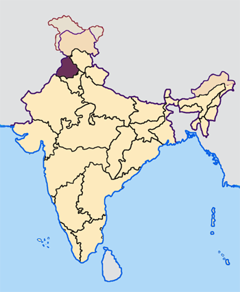
Map made by me, Nichalp
Note: The Indian state of w:Jammu and Kashmir is claimed by w:India, w:Pakistan and the w:People's Republic of China. This map depicts the boundaries of the state as it was in 1947. Areas administered by India is coloured as per the rest of the states, and the area administered by Pakistan and China are coloured in a neutral colour. See the map of Jammu and Kashmir.
The Indian state of w:Arunachal Pradesh is claimed by China as a part of w:South Tibet. The claimed region is depicted in a pale shade of pink. See the map of Arunachal Pradesh.
The Indian territorial waters extend to a distance of twelve nautical miles.

|
ھن دستاويز کي جي.اين.يو مفت دستاويزسازي اجازتنامي ، مفت سافٽويئر فائونڊيشن پاران ڇاپيل ورزن 1.2 يا ٻي ڪنھن بعد واري ورزن؛ جنھن ۾ نہ انويريئينٽ ڀاڱا، ۽ نہ فونٽ-ڪور متنَ، ۽ نہ بيڪ-ڪور متنَ شامل آھن، جي شرطن ھيٺ نقل ڪرڻ، ورھائن ۽/يا بدلائڻ جي اجازت ڏني وئي آھي. اجازتنامي جو نقل [[c:Commons:GNU Free Documentation License, version 1.2 | جي.اين.يو مفت دستاويزسازي اجازتنامو]] نالي ڀاڱي ۾ ڏنل آھي. |
| ھي فائيل ڪريئيٽو ڪامنز انتساب-ھڪجھڙي ڀاڱيداري 3.0 انپورٽڊ اجازتنامي ھيٺ اجازتنامو ڏنل آھي. | ||
| ||
| This licensing tag was added to this file as part of the GFDL licensing update. |
فائيل جي سوانح
ڪنھن بہ تاريخ/وقت تي ٽڙڪ ڪري ڏسندا تہ ان وقت اهو فائيل ڪيئن هو.
| تاريخ/وقت | آڱوٺي ننھن | ماپَ | واپرائيندڙ | راءِ | |
|---|---|---|---|---|---|
| موجود نسخو | 07:33, 23 اپريل 2005 | | 350 × 426 (76 KB) | Nichalp | NPOV map |
| 07:22, 23 اپريل 2005 |  | 200 × 231 (22 KB) | Kerpal | Reverted to earlier revision | |
| 06:27, 23 اپريل 2005 |  | 500 × 608 (121 KB) | Nichalp | Reverted to earlier revision | |
| 05:00, 23 اپريل 2005 |  | 200 × 231 (22 KB) | Kerpal | Reverted to earlier revision | |
| 04:54, 23 اپريل 2005 |  | 500 × 608 (121 KB) | Nichalp | Reverted to earlier revision | |
| 21:06, 22 اپريل 2005 |  | 200 × 231 (22 KB) | Kerpal | Reverted to earlier revision | |
| 13:38, 22 اپريل 2005 |  | 500 × 608 (121 KB) | Nichalp | Reverted to earlier revision | |
| 09:43, 22 اپريل 2005 |  | 200 × 231 (22 KB) | Kerpal | originally by en:User:Morwen | |
| 18:06, 21 اپريل 2005 |  | 500 × 608 (121 KB) | Nichalp | ---- Map made by me, ~~~ ---- Note: The Indian state of w:Jammu and Kashmir is claimed by w:India, w:Pakistan and the w:People's Republic of China. This map depicts the boundaries of the state as it was in 1947. Areas administered by Indi |
ڳنڍڻا
هن فائيل سان هيٺيان صفحا ڳنڍيل آهن.
گلوبل فائيل جو استعمال
ھيٺيون وڪيز بہ ھيءُ فائيل استعمال ڪن ٿيون:
- awa.wikipedia.org تي استعمال
- bh.wikipedia.org تي استعمال
- अमृतसर जिला
- बरनाला जिला
- भटिंडा जिला
- फिरोजपुर जिला
- फरीदकोट जिला
- फतेहगढ़ साहिब जिला
- फजिल्का जिला
- गुरदासपुर जिला
- होशियारपुर जिला
- जालंधर जिला
- कपूरथला जिला
- लुधियाना जिला
- मानसा जिला
- मोगा जिला
- श्री मुक्तसर साहिब जिला
- पठानकोट जिला
- पटियाला जिला
- रूपनगर जिला
- संगरूर जिला
- शहीद भगत सिंह नगर जिला
- तरनतारन जिला
- टेम्पलेट:पंजाब
- bn.wikipedia.org تي استعمال
- bxr.wikipedia.org تي استعمال
- en.wikipedia.org تي استعمال
ھن فائيل جو وڌيڪ گلوبل استعمال ڏسو.