
فائل:Map-of-southeast-asia 900 CE.png
هن پيش-نگاھ جي ماپ: 426*600 پڪزلس. ٻيا تحلل:170*240 پڪزلس | 341*480 پڪزلس | 791*1,114 پڪزلس
اصلوڪو فائيل (791 × 1,114 عڪسلون، فائيل سائيز: 182 KB، MIME ٽائيپ: image/png)
khmerempire3.jpg
تَتُ
| تشريح |
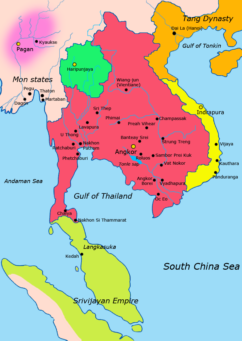
English: Map of Southeast Asia circa 900 CE, showing the Khmer Empire in red, Champa in yellow and Haripunjaya in light Green plus additional surrounding states.
sources i used for this work include http://ecaimaps.berkeley.edu/animations/2003_03_khmer_animation.swf http://www.britannica.com/EBchecked/media/3395/Khmer-empire-1200 Atlas of world history, Patrick Karl O'brien Societies, Networks, and Transitions: A Global History, Volume B. Craig A.Lockard http://upload.wikimedia.org/wikipedia/commons/thumb/4/45/Srivijaya_Empire.svg/2000px-Srivijaya_Empire.svg.png File:DvaravatiMapThailand.png http://upload.wikimedia.org/wikipedia/commons/e/eb/Thailand_2002_CIA_map.jpgBahasa Indonesia: Peta Asia Tenggara sekitar tahun 900 M, menampilkan Kerajaan Khmer dengan warna merah, Champa dengan warna kuning dan Haripunjaya dengan warna hijau beserta beberapa negara-negara lainnya. |
|||
| تاريخ | ||||
| ذريعو | ڪم پنھنجايو | |||
| ليکڪ | Javierfv1212 | |||
| Other versions |
|


لائيسنسڪاري
I, the copyright holder of this work, hereby publish it under the following license:
| هي ڪم ڪريئيٽو ڪامنز سيسي0 1.0 عالمي عوامي کاتي ھيٺ موجود آھي. | |
| جيڪو ماڻھو هن ڪم سان لاڳاپيل آهي، ان پنھنجي ڪم کي وقف ڪيو آهي عوامي کاتي ۾ عالمي حق ۽ واسطن جي قانون ۽ لاڳاپيل قانونن موجب. اوهان هن ڪم کي نقل، سنوار، ونڊ ڪري سگهو ٿا، ايتري قدر جو اوهان بغير اجازت جي تجارتي مقصدن لاءِ هي ڪم استعمال ڪري سگهو ٿا.
|
فائيل جي سوانح
ڪنھن بہ تاريخ/وقت تي ٽڙڪ ڪري ڏسندا تہ ان وقت اهو فائيل ڪيئن هو.
| تاريخ/وقت | آڱوٺي ننھن | ماپَ | واپرائيندڙ | راءِ | |
|---|---|---|---|---|---|
| موجود نسخو | 14:13, 8 اپريل 2011 | | 791 × 1,114 (182 KB) | Ras67 | cropped |
| 02:13, 28 مارچ 2011 |  | 800 × 1,125 (222 KB) | Javierfv1212 | {{Information |Description ={{en|1=Map of South-east asia circa 900 CE, showing the Khmer Empire in red, Champa in yellow and Haripunjaya in light Green plus additional surrounding states. sources i used for this work include http://ecaimaps.berkele |
ڳنڍڻا
هن فائيل سان هيٺيان صفحا ڳنڍيل آهن.
گلوبل فائيل جو استعمال
ھيٺيون وڪيز بہ ھيءُ فائيل استعمال ڪن ٿيون:
- af.wikipedia.org تي استعمال
- ar.wikipedia.org تي استعمال
- azb.wikipedia.org تي استعمال
- az.wikipedia.org تي استعمال
- bg.wikipedia.org تي استعمال
- ceb.wikipedia.org تي استعمال
- cs.wikipedia.org تي استعمال
- el.wikipedia.org تي استعمال
- en.wikipedia.org تي استعمال
- eo.wikipedia.org تي استعمال
- et.wikipedia.org تي استعمال
- eu.wikipedia.org تي استعمال
- fa.wikipedia.org تي استعمال
- fi.wikipedia.org تي استعمال
- fr.wikipedia.org تي استعمال
- gu.wikipedia.org تي استعمال
- he.wikipedia.org تي استعمال
- id.wikipedia.org تي استعمال
- it.wikipedia.org تي استعمال
- ja.wikipedia.org تي استعمال
- ka.wikipedia.org تي استعمال
- km.wikipedia.org تي استعمال
- lo.wikipedia.org تي استعمال
- lt.wikipedia.org تي استعمال
- mg.wikipedia.org تي استعمال
- ml.wikipedia.org تي استعمال
- mn.wikipedia.org تي استعمال
ھن فائيل جو وڌيڪ گلوبل استعمال ڏسو.